Neha Patil (Editor)

Pedra, Pernambuco

Updated on
Edit
Like
Comment
Share on FacebookTweet on TwitterShare on LinkedInShare on Reddit
Area
  
803 km²

Pedra, Pernambuco mw2googlecommwpanoramiophotosmedium50070617jpg

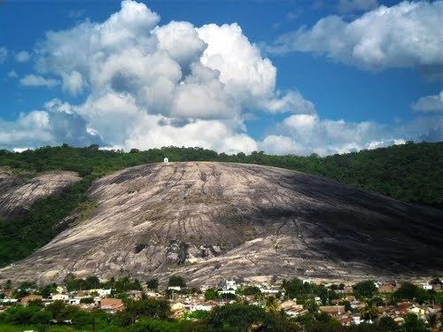
Pedra (stone) is a city located in the state of Pernambuco, Brazil. Located at 255 km away from Recife, capital of the state of Pernambuco. Has an estimated (Ibge 2009) population of 20.788 inhabitants.

Contents

Map of Pedra - State of Pernambuco, Brazil

Geography

  • State - Pernambuco
  • Region - Agreste Pernambucano
  • Boundaries - Arcoverde and Pesqueira (N); Águas Belas (S); Caetés, Paranatama and Venturosa (E); Buique (W)
  • Area - 803.02 km2
  • Elevation - 593 m
  • Hidrography - Ipanema River
  • Vegetation - Caatinga Hipoxerófila
  • Clima - Semi arid - hot
  • Annual average temperature - 22.9 c
  • Distance to Recife - 255.4 km
  • Economy

    The main economic activities in Pedra are based in commerce and agribusiness, especially manioc, beans, tomatoes, corn; and livestock such as cattle, pigs, sheep, goats, horses and chickens.

    Economic indicators

    Economy by Sector 2006

    References

    Pedra, Pernambuco Wikipedia