
Country Brasil Lowest elevation 41 m (135 ft) Area 133.4 km² | Highest elevation 116 m (381 ft) Neighbourhoods 1 | |
 | ||
Passo do Verde ([ˈpasu du ˈvɛrdʒi], "green pitch") is a district of the municipality of Santa Maria, in the Brazilian state of Rio Grande do Sul. It is situated in the south portion of Santa Maria. The district's seat is located 23 km (14,29 miles) from Downtown Santa Maria, nearby the Vacacaí River close to the boundary of Santa Maria with São Sepé.
Contents
The district of Passo do Verde owns an area of 133.40 km² that is equivalent to 7.45% of the municipality of Santa Maria that is 1791,65 km².
History
The district was created in April 19, 1994, by municipal law 3770/94 with area deducted from district of Santa Flora.
Geography
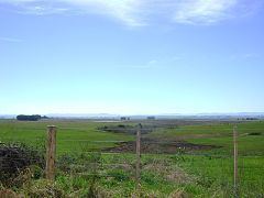
The district is situated in the south portion of municipality of Santa Maria. Altogether the relief is suavely undulating and is characterized by the presence of floodplains and coxilhas without big difference with its altimetric elevations.
Limits
The district limits with the districts of Arroio do Só, Pains and Santa Flora, and, with the municipalities of Formigueiro and São Sepé.
Neighbourhoods
The district of Passo do Verde is divided in the following bairros, that in English is equivalent to neighbourhoods: