
Country United States County Passaic Time zone Eastern (EST) (UTC-5) Zip code 07403 Local time Sunday 2:56 AM | Incorporated February 23, 1918 Elevation 167 m Population 7,742 (2013) | |
 | ||
Area rank 218th of 566 in state6th of 16 in county Weather -11°C, Wind NW at 13 km/h, 41% Humidity | ||
Bloomingdale is a borough in Passaic County, New Jersey, United States. As of the 2010 United States Census, the borough's population was 7,656, reflecting an increase of 46 (+0.6%) from the 7,610 counted in the 2000 Census, which had in turn increased by 80 (+1.1%) from the 7,530 counted in the 1990 Census.
Contents
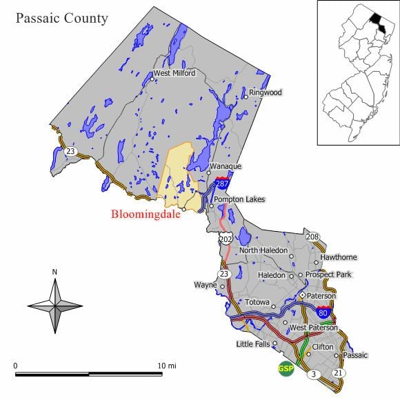
- Map of Bloomingdale NJ USA
- History
- Geography
- Census 2010
- Census 2000
- Local government
- Federal state and county representation
- Highlands protection
- Politics
- Education
- Roads and highways
- Public transportation
- Notable people
- References
Map of Bloomingdale, NJ, USA
History
Bloomingdale's Federal Hill was the site of the 1781 Pompton Mutiny, a winter revolt of Continental Army troops that was crushed by General Robert Howe on direct orders of General George Washington.
Growth in Bloomingdale was driven by the development in the late 1860s of a rubber mill and other factories in neighboring Butler. The New Jersey Midland Railroad, later known as the New York, Susquehanna and Western Railway, laid tracks adjacent to the settlement, with a Bloomingdale station located in what today is Riverdale. The northern section of Riverdale and most of Butler were known as East Bloomingdale and West Bloomingdale respectively during most of the 19th century. Despite crossing a county border, they also shared a school district and residents considered the whole area as "Bloomingdale" until about 1881 when a Post Office named Butler was designated. This began a period of rivalry which caused a schism between the residents of Butler and Bloomingdale resulting in separate schools, churches and even town bands.
Bloomingdale was incorporated as an independent borough on February 23, 1918, when Pompton Township was split up into three new municipalities along with Wanaque and Ringwood. Prior to that, the area was known as Bloomingdale throughout the 19th century and was initially a farming community starting about 1712 with the "Bloomingdale Forge" built shortly thereafter to take advantage of the iron in the hills. The business district along the Paterson-Hamburg Turnpike and the Pequannock River began about the middle of the 19th century.
Bloomingdale, like most municipalities in North Jersey, is a suburb of New York City. Some of the things that still link Bloomingdale to its past are its two churches (Methodist and Baptist), the Samuel R. Donald School (originally built in 1886) and the Bloomingdale Cornet Band continuously active since 1884.
DeLazier Field, used by the Triboro Little League, was the home field for the Minor League Baseball team known as the Bloomingdale Troopers of the North Atlantic League from 1946 to 1948.
The History of Bloomingdale can be found in three separate books published by the borough in 1958, 1968 and 1993. Additionally, more history can be found in microfilmed local newspapers located at the Butler Museum, the Morristown Library, the Paterson Library and the New Jersey State Archives.
Geography
According to the United States Census Bureau, the borough had a total area of 9.166 square miles (23.739 km2), including 8.714 square miles (22.570 km2) of land and 0.452 square miles (1.170 km2) of water (4.93%).
Unincorporated communities, localities and place names located partially or completely within the borough include Cold Spring Lake, Glenwild Lake, Iosco Lake, Lake Kampfe, Morse Lakes, Mothers Lake, Norvin Green State Forest, Pompton Junction, Star Lake and Twilliger Lake.
The borough borders Pompton Lakes, Ringwood, Wanaque and West Milford Township in Passaic County and both Butler and Riverdale in Morris County.
Census 2010
The 2010 United States Census counted 7,656 people, 2,935 households, and 2,034 families residing in the borough. The population density was 878.6 per square mile (339.2/km2). The borough contained 3,089 housing units at an average density of 354.5 per square mile (136.9/km2). The racial makeup of the borough was 91.97% (7,041) White, 1.14% (87) Black or African American, 0.22% (17) Native American, 2.46% (188) Asian, 0.00% (0) Pacific Islander, 3.03% (232) from other races, and 1.19% (91) from two or more races. Hispanics or Latinos of any race were 9.33% (714) of the population.
Out of a total of 2,935 households, 29.8% had children under the age of 18 living with them, 56.0% were married couples living together, 8.9% had a female householder with no husband present, and 30.7% were non-families. 25.1% of all households were made up of individuals, and 8.1% had someone living alone who was 65 years of age or older. The average household size was 2.57 and the average family size was 3.10.
In the borough, 21.1% of the population were under the age of 18, 6.4% from 18 to 24, 27.7% from 25 to 44, 29.9% from 45 to 64, and 14.8% who were 65 years of age or older. The median age was 41.8 years. For every 100 females the census counted 96.8 males, but for 100 females at least 18 years old, it was 96.4 males.
The Census Bureau's 2006-2010 American Community Survey showed that (in 2010 inflation-adjusted dollars) median household income was $79,044 (with a margin of error of +/- $15,773) and the median family income was $103,972 (+/- $5,906). Males had a median income of $56,974 (+/- $6,604) versus $47,204 (+/- $7,582) for females. The per capita income for the borough was $32,417 (+/- $3,746). About 3.3% of families and 5.7% of the population were below the poverty line, including 5.7% of those under age 18 and 0.0% of those age 65 or over.
Same-sex couples headed 23 households in 2010, up from the 14 counted in 2000.
Census 2000
As of the 2000 United States Census there were 7,610 people, 2,847 households, and 2,078 families residing in the borough. The population density was 864.7 people per square mile (333.9/km2). There were 2,940 housing units at an average density of 334.1 per square mile (129.0/km2). The racial makeup of the borough was 95.55% White, 0.42% African American, 0.12% Native American, 2.19% Asian, 0.67% from other races, and 1.05% from two or more races. Hispanic or Latino of any race were 4.36% of the population.
There were 2,847 households out of which 31.8% had children under the age of 18 living with them, 60.9% were married couples living together, 8.7% had a female householder with no husband present, and 27.0% were non-families. 21.9% of all households were made up of individuals and 6.2% had someone living alone who was 65 years of age or older. The average household size was 2.63 and the average family size was 3.09.
In the borough the population was spread out with 22.3% under the age of 18, 6.4% from 18 to 24, 34.3% from 25 to 44, 25.2% from 45 to 64, and 11.9% who were 65 years of age or older. The median age was 38 years. For every 100 females there were 97.8 males. For every 100 females age 18 and over, there were 94.9 males.
The median income for a household in the borough was $67,885, and the median income for a family was $75,433. Males had a median income of $46,351 versus $36,607 for females. The per capita income for the borough was $27,736. 3.4% of the population and 2.0% of families were below the poverty line. Out of the total people living in poverty, 3.8% are under the age of 18 and 3.5% are 65 or older.
Local government
Bloomingdale is governed under the Borough form of New Jersey municipal government. The governing body consists of a Mayor and a Borough Council comprising six council members, with all positions elected at-large on a partisan basis as part of the November general election. A Mayor is elected directly by the voters to a four-year term of office. The Borough Council consists of six members elected to serve three-year terms on a staggered basis, with two seats coming up for election each year in a three-year cycle. The Borough form of government used by Bloomingdale, the most common system used in the state, is a "weak mayor / strong council" government in which council members act as the legislative body with the mayor presiding at meetings and voting only in the event of a tie. The mayor can veto ordinances subject to an override by a two-thirds majority vote of the council. The mayor makes committee and liaison assignments for council members, and most appointments are made by the mayor with the advice and consent of the council.
As of 2016, the Mayor of the Borough of Bloomingdale is Democrat Jonathan Dunleavy, whose term of office ends December 31, 2018. Members of the Bloomingdale Borough Council are Council President Michael S. Sondermeyer (D, 2018), Anthony J. Costa (D, 2016), John D'Amato (D, 2017), Richard C. Dellaripa Jr. (D, 2018), Dawn R. Hudson (D, 2016) and Peyman "Ray" Yazdi (D, 2017).
Federal, state and county representation
Bloomingdale is located in the 11th Congressional District and is part of New Jersey's 39th state legislative district. Prior to the 2011 reapportionment following the 2010 Census, Bloomingdale had been in the 26th state legislative district. Prior to the 2010 Census, Bloomingdale had been part of the 5th Congressional District and the 11th Congressional District, a change made by the New Jersey Redistricting Commission that took effect in January 2013, based on the results of the November 2012 general elections.
New Jersey's Eleventh Congressional District is represented by Rodney Frelinghuysen (R, Harding Township). New Jersey is represented in the United States Senate by Cory Booker (D, Newark, term ends 2021) and Bob Menendez (D, Paramus, 2019).
For the 2016–2017 session (Senate, General Assembly), the 39th Legislative District of the New Jersey Legislature is represented in the State Senate by Gerald Cardinale (R, Demarest) and in the General Assembly by Holly Schepisi (R, River Vale) and Robert Auth (R, Old Tappan). The Governor of New Jersey is Chris Christie (R, Mendham Township). The Lieutenant Governor of New Jersey is Kim Guadagno (R, Monmouth Beach).
Passaic County is governed by a seven-member Board of Chosen Freeholders, who are elected at-large to staggered three-year terms office on a partisan basis, with two or three seats coming up for election each year as part of the November general election in a three-year cycle. At a reorganization meeting held in January, the board selects a Director and Deputy Director from among its members to serve for a one-year term. As of 2015, Passaic County's Freeholders are John W. Bartlett (D, 2015; Wayne), Theodore O. Best, Jr. (D, 2017; Paterson), Ronda Cotroneo (D, 2015; Ringwood), Terry Duffy (D, 2016; West Milford), and Pat Lepore (D, 2016; Woodland Park). The last seat, vacated by Hector Lora who resigned to become mayor of Passaic, is still up for discussion as of December 2016. Constitutional officers elected on a countywide basis are County Clerk Kristin M. Corrado (R, 2019), Sheriff Richard H. Berdnik (2016) and Surrogate Bernice Toledo (2016).
Highlands protection
In 2004, the New Jersey Legislature passed the Highlands Water Protection and Planning Act, which regulates the New Jersey Highlands region. Bloomingdale was included in the highlands preservation area and is subject to the rules of the act and the Highlands Water Protection and Planning Council, a division of the New Jersey Department of Environmental Protection. Some of the territory in the protected region is classified as being in the highlands preservation area, and thus subject to additional rules.
Politics
As of March 23, 2011, there were a total of 4,993 registered voters in Bloomingdale, of which 1,333 (26.7% vs. 31.0% countywide) were registered as Democrats, 1,154 (23.1% vs. 18.7%) were registered as Republicans and 2,505 (50.2% vs. 50.3%) were registered as Unaffiliated. There was one voter registered to another party. Among the borough's 2010 Census population, 65.2% (vs. 53.2% in Passaic County) were registered to vote, including 82.7% of those ages 18 and over (vs. 70.8% countywide).
In the 2012 presidential election, Republican Mitt Romney received 51.7% of the vote (1,849 cast), ahead of Democrat Barack Obama with 46.7% (1,670 votes), and other candidates with 1.6% (57 votes), among the 3,608 ballots cast by the borough's 5,215 registered voters (32 ballots were spoiled), for a turnout of 69.2%. In the 2008 presidential election, Republican John McCain received 2,077 votes (53.1% vs. 37.7% countywide), ahead of Democrat Barack Obama with 1,732 votes (44.3% vs. 58.8%) and other candidates with 50 votes (1.3% vs. 0.8%), among the 3,911 ballots cast by the borough's 5,159 registered voters, for a turnout of 75.8% (vs. 70.4% in Passaic County). In the 2004 presidential election, Republican George W. Bush received 2,078 votes (55.2% vs. 42.7% countywide), ahead of Democrat John Kerry with 1,603 votes (42.6% vs. 53.9%) and other candidates with 39 votes (1.0% vs. 0.7%), among the 3,767 ballots cast by the borough's 4,996 registered voters, for a turnout of 75.4% (vs. 69.3% in the whole county).
In the 2013 gubernatorial election, Republican Chris Christie received 68.6% of the vote (1,599 cast), ahead of Democrat Barbara Buono with 29.9% (697 votes), and other candidates with 1.5% (36 votes), among the 2,370 ballots cast by the borough's 5,219 registered voters (38 ballots were spoiled), for a turnout of 45.4%. In the 2009 gubernatorial election, Republican Chris Christie received 1,401 votes (54.3% vs. 43.2% countywide), ahead of Democrat Jon Corzine with 934 votes (36.2% vs. 50.8%), Independent Chris Daggett with 191 votes (7.4% vs. 3.8%) and other candidates with 30 votes (1.2% vs. 0.9%), among the 2,580 ballots cast by the borough's 4,932 registered voters, yielding a 52.3% turnout (vs. 42.7% in the county).
Education
The Bloomingdale School District serves public school students in Kindergarten through eighth grade. As of the 2011-12 school year, the district's three schools had an enrollment of 613 students and 49.6 classroom teachers (on an FTE basis), for a student–teacher ratio of 12.36:1. Schools in the district (with 2011-12 enrollment data from the National Center for Education Statistics) are Martha B. Day Elementary School (153 students; grades K-1), Samuel R. Donald Elementary School (204; 2-4) and Walter T. Bergen Middle School (256; 5-8).
For ninth through twelfth grades, high school-aged students from Bloomingdale in public school attend Butler High School in the adjacent community of Butler in Morris County, as part of a sending/receiving relationship with the Butler Public Schools.
Roads and highways
As of May 2010, the borough had a total of 29.54 miles (47.54 km) of roadways, of which 21.04 miles (33.86 km) were maintained by the municipality, 7.88 miles (12.68 km) by Passaic County and 0.62 miles (1.00 km) by the New Jersey Department of Transportation.
Public transportation
Bloomingdale was served by the New York, Susquehanna and Western Railway commuter passenger service until 1966. NJ Transit provides bus transportation on the 194 route to the Port Authority Bus Terminal in Midtown Manhattan. In September 2012, as part of budget cuts, NJ Transit suspended service to Newark on the 75 line.
Notable people
People who were born in, residents of, or otherwise closely associated with Bloomingdale include: