
Postal code 462 00 Website www.dimos-souliou.gr Area code 26660 | Time zone EET (UTC+2) Vehicle registration ΗΝA - HNB - IE Local time Thursday 12:47 AM | |
 | ||
Weather 12°C, Wind NE at 3 km/h, 88% Humidity | ||
Paramythia (Greek: Παραμυθιά, Paramythiá) is a town and a former municipality in Thesprotia, Epirus, Greece. Since the 2011 local government reform it is part of the municipality Souli, of which it is the seat and a municipal unit. The municipal unit has an area of 342.197 km2. The town's population is 2,730 as of the 2011 census.
Contents
- Map of Paramythia 462 00 Greece
- Name
- Geography
- Antiquity
- Medieval era
- Modern era
- Notable inhabitants
- Subdivisions
- References
Map of Paramythia 462 00, Greece
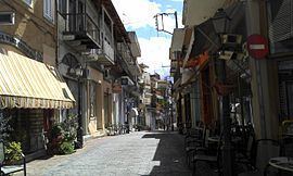
Paramythia acts as a regional hub for several small villages in the Valley of Paramythia, and features shops, schools, a gym, a stadium and a medical center. Primary aspects of the economy are agriculture and trade. The town is build on the slopes of Mount Gorilla and overlooks the valley, below. The Castle of Paramythia was built on a hill in one of the highest points of the town during the Byzantine period and today is open to the tourists.
The modern Egnatia Highway which links Igoumenitsa with Ioannina, goes through the valley, north of the town of Paramythia.
Name
The name "Paramythia" derives from one of the Virgin Mary's names in Greek ("Paramythia" in Greeks means comforter). During the Byzantine era the town was also known as Agios Donatos (Greek: Άγιος Δονάτος), after Saint Donatus of Evorea, the town's patron saint. This is also the basis of the Albanian and the Turkish name of Paramythia, Ajdhonat, Ajdonat, Ajdonati and Aydonat.
Geography
The Paramythia municipal unit consists of 23 communities. The total population of the municipal unit is 7,459 (2011). The town of Paramythia itself has a population of 2,730 and lies in an amphitheatre at an altitude of 750 m, at the foot of Mount Gorilla, between the Acheron and the Kalamas rivers. The Gorilla range (altitude 1,658 m) lies on the eastern side of the city and the Chionistra (1,644 m) to the Northeast. At the city limits is the Kokytos (Cocytus) River, one of the rivers of the underworld in Greek mythology. Paramythia's valley is one of the largest in Thesprotia and is one of the major agricultural areas in Epirus.
Antiquity
The earliest known inhabitants of the area were the Greek tribe of the Chaonians. Late bronze antiquities have been found in the "Tsardakia" area were a Mycenean settlement probably existed. Paramythia has been identified with the ancient Chaonian city of Photike (Greek: Φωτική), named after Photios, a leader of the Chaonians. A famous hoard of bronzes dating from the mid 2nd Century AD, nineteen bronze sculptures were discovered during the 1790s, near the village of Paramythia. Soon after their discovery, the hoard was dispatched to St Petersburg, to become part of Catherine the Great's collection. After her death, the original hoard was dispersed to various European collections. Eventually fourteen of the statuettes reached the British Museum.
Medieval era
Photike, as with the rest of Epirus, became part of the Roman and subsequently Byzantine Empires. In the late Roman era it was the seat of a Bishopric and was renamed after Saint Donatus of Evorea.
Following the fall of Constantinople to the Fourth Crusade in 1204, Paramythia became part of the Despotate of Epirus. The Despotate remained independent for the next two centuries, maintaining the Greek Byzantine traditions. For a brief period in the 14th century (1358–1367), Paramythia came under the rule of the Albanian chieftain Gjin Bua Shpata, but returned to the Despotate of Epirus by despot Thomas II Preljubović, before falling to the Ottomans in 1449. Paramythia was part of the Ottoman Sanjak of Ioannina.
Modern era
A Greek language school, had been attested since 1682. It declined and close in the mid-18th century, however, another Greek school was continuously operating from the late 17th century and at 1842 was expanded with additional classes. In 1854 a major revolt took place in Epirus and the town came briefly under the control of guerilla Souliote forces that demanded the union of Epirus with Greece.
After the end of the Balkan Wars (1912–1913) the town became part of the Greek state, as with the rest of Epirus region. Until the Second World War the town had a mixed population of Greeks and Cham Albanians. During the Greek-Italian War the town was burned by Cham Albanian bands (October 28-November 14, 1940) Almost all buildings inhabited by Muslim Albanians in the town were destroyed during World War II warfare.
On the night of 27 September 1943, Cham militias arrested 53 Greek citizens in Paramythia and executed 49 of them two days later. This action was orchestrated by the brothers Nuri and Mazar Dino (an officer of the Cham militia) in order to get rid of the town's Greek representatives and intellectuals. According to German reports, Cham militias were also part of the firing squad.
During September 20–29, as a result of serial terrorist activities, at least Greek 75 citizens were killed in Paramythia and 19 municipalities were destroyed. On September 30, the Swiss representative of the International Red Cross, Hans-Jakob Bickel, visited the area and confirmed the atrocities committed by the Cham militia in collaboration with the Axis forces.
Notable inhabitants
Subdivisions
The municipal unit Paramythia is subdivided into the following communities (constituent villages in brackets):