
Native name Rio Paraguaçu | Length 600 km | |
 | ||
River mouth Baía de Todos os Santos | ||
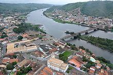
Must see sailing rio paragua u river day5
The Paraguaçu River is a river in Bahia state of eastern Brazil.
Contents
- Must see sailing rio paragua u river day5
- Map of Rio ParaguaC3A7u State of Bahia Brazil
- Course
- History
- References
Map of Rio Paragua%C3%A7u, State of Bahia, Brazil
Course
The Paraguaçu River originates in the Chapada Diamantina highlands of central Bahia following the chain of mountains called Sincura and flows east 500 kilometres (310 mi) to empty into the Baía de Todos os Santos.
The river widens into the Iguape Bay at the end of its course, an arm of the Bay of All Saints (Baia de Todos os Santos). The Iguape Bay is protected by the 10,074 hectares (24,890 acres) Baía do Iguape Marine Extractive Reserve, created in 2000.
History
The river's course followed a rich vein of diamonds which led to an influx of prospectors. These mines have taken their name from the mountain range to be known cumulatively as the mines of Sincura.
The river flooded in December 1989 following heavy rain. The flood affected 175 towns and cities and caused landslides. The flooding killed 35 and displaced 200,000 people.