
Population 151 (2011 census) Pampas Tummaville | Postcode(s) 4352 Postal code 4352 | |
 | ||
Pampas is a locality in the Toowoomba Region, Queensland, Australia. At the 2011 Australian Census Pampas and surrounds recorded a population of 151.
Contents
Map of Pampas QLD 4352, Australia
Geography
The locality is positioned between the main channel and north branch of the Condamine River both of which mark boundaries. The Millmerran railway line and Gore Highway pass through Pampas.
History
Pampas is named because of the extensive coverage kangaroo grass.
The Dry Paddock Provisional School opened on 9 August 1897. In 1909 it became Pampas State School. The Pampas State School closed on 27 December 1957.
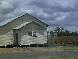
Amenities
Pampas has a Memorial Hall located on the Gore Highway.
References
Pampas, Queensland Wikipedia(Text) CC BY-SA