
Length .81 mi (1.30 km) | Area .31 sq mi (0.80 km) | |
 | ||
Similar Palisades, Sierra Nevada, Big Pine Creek, Mount Sill, North Palisade | ||
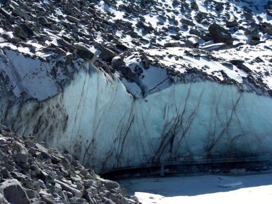
The Palisade Glacier is located on the northeast side of the Palisades within the John Muir Wilderness in the central Sierra Nevada of California. The glacier descends from the flanks of four mountain peaks over 14,000 ft (4,300 m) in elevation of which North Palisade (14,242 ft (4,341 m)) is third highest peak in the Sierra Nevada Range.
Map of Palisade Glacier, California 93513, USA
The cirque containing the Palisade Glacier has a history of thousands of years of glaciation. The modern glacier attained its last maximum extent during the Little Ice Age, between 250 and 170 years ago (a period also known as the Matthes glaciation in the Sierra Nevada). It currently has an area of .31 sq mi (0.80 km2) and the glacier is .81 mi (1.30 km) long and .50 mi (0.80 km) wide. It is located between 13,400 and 12,000 ft (4,100 and 3,700 m) and moves at a rate of 20 ft (6.1 m) per year, although it is also retreating. Palisade Glacier is one of the few glaciers in California that terminates in a proglacial lake dammed by its former moraine and the lake is turquoise colored from the glacial powder suspended in the water. The Big Pine Lakes below the glacier are also the same color. Another feature of the glacier is a moulin, which was formed in a drought during 1977, and a bergschrund.