
Area 5.81 km² | ||
 | ||
Ame lie les bains palalda
Palalda is a former commune in Pyrénées-Orientales, now part of Amélie-les-Bains-Palalda.
Contents
- Ame lie les bains palalda
- Map of Palalda 66110 AmC3A9lie les Bains Palalda France
- Desfilada del festival folklorique d am lie les bains palalda 2015
- Geography
- History
- Canton
- Demography
- Sites of interest
- Culture
- References
Map of Palalda, 66110 Am%C3%A9lie-les-Bains-Palalda, France
Desfilada del festival folklorique d am lie les bains palalda 2015
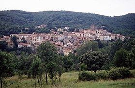
Geography
Palalda is located above the river Tech, to the northeast of Amélie-les-Bains and to the east of Montbolo.
History
The first mention of Palalda is from the year 814, as being the western limit of the territory of Céret.
On 1 October 1942, the commune of Palalda is linked to Amélie-les-Bains to create the new commune of Amélie-les-Bains-Palalda.
Canton
In 1790, Palalda is included in the canton of Arles, which remains the same after being united to Amélie-les-bains in 1942.
Demography
Population under the Ancien Régime is calculated either in number of feu fiscal (f, fire tax), or in number of inhabitants (H).
Sites of interest
Culture
References
Palalda Wikipedia(Text) CC BY-SA