
Intercommunality Haut Vallespir Area 21.98 km² | Region Occitanie Population (1999) 145 Local time Friday 11:49 PM | |
 | ||
Weather 11°C, Wind NW at 10 km/h, 65% Humidity | ||
Montbolo
Montbolo (Catalan: Montboló) is a commune in the Pyrénées-Orientales department in southern France.
Contents
- Montbolo
- Map of 66110 Montbolo France
- Sentier pedestre de montbolo vtt vallespir
- Localization
- Geology
- Sites of interest
- References
Map of 66110 Montbolo, France
Sentier pedestre de montbolo vtt vallespir
Localization
Montbolo is located in the canton of Arles-sur-Tech and in the arrondissement of Céret.
Geology
Montbolo once had gypsum mines, used for making plaster, and also lutite and dolostone. A landslide in a gypsum stone-pit in Montbolo occurred on 20 March 1886 and killed three workers.
Sites of interest
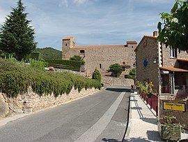
The Saint-Andrew church of Montbolo was first built in the 12th century and then modified in the 13th, 14th and 17th centuries. At the end of 19th century works started for a full repair of the church, but the new roof was entirely destroyed following a storm in January 1900. Other repairs have been made more recently, such as the rebuild of the portal, which destroyed some of the older elements.
Montbolo has two dolmens : the Caixa de Rotllan, on the city limit with Arles-sur-Tech and the dolmen de Formentera.