
Topo map USGS Owens Peak Elevation 2,576 m Mountain range Sierra Nevada | Easiest route Hike, class 2 Prominence 662 m Parent range Sierra Nevada | |
 | ||
Listing Sierra Peaks SectionHundred Peaks Section Similar Olancha Peak, Sirretta Peak, Sawtooth Peak, The Needles, Mount Morgan | ||
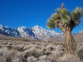
Owens Peak is the highest point in the southern Sierra Nevada Mountains at more than 8,400 feet. The peak stands near the center of the Owens Peak Wilderness which was designated by United States Congress in 1994, and it now has a total of 74,060 acres (299.7 km2). The eastern watershed of Owens Peak is composed of three main canyons: Grapevine Canyon, Short Canyon, and Indian Wells Canyon (north to south, respectively). The Sierra Nevada meets the Great Basin and the Mojave Desert here, creating an unusual ecosystem.
Contents
Map of Owens Peak, California 93255, USA
Owens Peak is located in Kern County, about 12 miles west-northwest of Inyokern, 159 miles from Los Angeles.
HistoryEdit
Owens Peak is named after Richard Owens (1812–1902), an Ohio born explorer (aka "Owings"), who accompanied John C. Fremont on his third expedition to California (1845–1946). Fremont also named a valley, river and lake for Owens, whom he considered "cool, brave and of good judgment". Owens served as Captain in Fremont's California Battalion during the Mexican-American War, and was California's Secretary of State during Fremont's brief tenure as Governor (1847).