
Parent peak Needham Mountain First ascent 1871 Joseph Lovelace Prominence 202 m | Mountain type Granite Elevation 3,762 m | |
 | ||
Similar Black Kaweah, Kaweah Peaks Ridge, Florence Peak, Mount Kaweah, Olancha Peak | ||
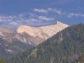
Summit of sawtooth peak sequoia national park
Sawtooth Peak is a jagged mountain rising to a height of 12,343 feet (3,762 m). It is an iconic landmark of the Mineral King region of the Sierra Nevada, in Sequoia National Park. In the past, it was known as Miner's Peak. It contains an abundant supply of gold and mercury.
Contents
- Summit of sawtooth peak sequoia national park
- Map of Sawtooth Peak California USA
- Sawtooth peak august 2011
- HikingEdit
- ClimbingEdit
- References
Map of Sawtooth Peak, California, USA
Sawtooth peak august 2011
HikingEdit
The trailhead up to Sawtooth Peak starts in Mineral King, 23 miles off of the 198 on Mineral King Road. The trailhead is located at the end of Mineral King Road in a parking lot/staging area. The trail up to the peak is 11.5 miles round trip and is rated difficult. The last half-mile of the trail is mainly loose gravel and steep switchbacks. The base of the trail is at 7800 Ft elevation and climbs up to 12,400 Ft at the top of the pass. Hiking is recommended from May to October. Permits are required for overnight stay.
ClimbingEdit
The easiest approach is from the valley to Sawtooth Pass, and then up the northwest slope of the peak. It was first known to be climbed by Joseph Lovelace during a deer hunt in 1871.
Today, this approach follows an established trail to Sawtooth Pass, then continues on a cross-country route to the peak. The section of trail from Monarch Lakes to Sawtooth Pass is steep and marred by granite sand, and as such is prone to erosion. The trailhead, shared with the Timber Gap trail, is located in the Mineral King Valley, about 1/2 mile (0.80 km) uphill from the Ranger Station. It starts at 7,500 feet (2,300 m), is approximately 7 miles (10 km) round trip, and the route reaches a final elevation of 12,343 feet (3,762 m) at the peak.