
Existed: 2008 – present Length 158 km | Constructed 2008 | |
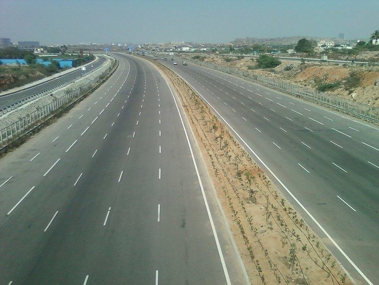 | ||
Outer Ring Road (officially:Nehru Outer Ring Road) is a 158 kilometer, 8-lane ring road expressway encircling the City of Hyderabad, Telangana, India. It is built by HMDA at a cost of Rs.6,696 crores. with an assistance of Rs 3,123 crores from Japan International Cooperation Agency. The expressway is designed for speeds up to 120 km/h. A large part, 124 km (covering urban nodes viz., Hi- Tech city, Nanakramguda Financial District, Hyderabad International Airport, IKP Knowledge park, Hardware Park, Telangana State Police Academy, Singapore Financial District, and Games village) of the 158-km was opened by December 2012.
Contents
- Map of Nehru Outer Ring Road Telangana
- Objective
- History
- Opening timeline
- Under Construction
- Exit Entry Junctions
- Land Acquisition
- Criticism
- References
Map of Nehru Outer Ring Road, Telangana
It gives an easy connectivity between NH 44, NH 65, NH 161, NH 163 and NH 765 from Hyderabad to Srisailam as well as state highways leading to Vikarabad Nagarjunasagar and Karimnagar /Mancherial. The Ring Road also helps in reducing the travel time from Rajiv Gandhi International Airport to cities like Nizamabad & Adilabad as it connects to NH44. The expressway is fenced and 33 radial roads connect it with the Inner Ring Road, and the upcoming Regional Ring Road.
Objective
The road aims to improve connectivity and decongest the traffic flow on the existing major arterials between the outer suburbs of Greater Hyderabad. The state-run TSRTC is planning to build 22 terminals-cum-depots (TCD) along the Outer Ring Road.
The objectives are:
History
The traffic studies on NH 44 and NH 65 concluded that a 4/6 lane road is due. The traffic movement on the existing inner ring road proved that the existing 4-lane road was inadequate. Due to the anticipated growth in the region and the development of proposed satellite townships around the ring road and beyond, an 8-lane carriageway was planned with a design life of 20 years.
The conclusion to develop a highway with access control provides highway grade separations or interchanges for all intersecting highways. Once it had been decided to develop the route as an expressway, all intersecting highways should be terminated, rerouted or provided with a grade separation. The proposed corridor was access-controlled and limited access was to be provided at National Highway/SHI Major road crossings. A 2-lane service roads designed to carry two-way traffic, were proposed on both sides of the corridor. Low level underpasses were to be provided for connecting both the service roads at every 1–2 km, where the terrain permits.
The project is to be implemented in 2 phases and is estimated to cost Rs 3000 Crores.
The construction started in December 2005. It is completed in a phased manner by June 2016 after delays. But Work is still pending on Kandlakoya gap on NH44 junction at Medchal which is delayed due to court case.
Opening timeline
Under Construction
Exit & Entry Junctions
There are 14 junctions on the Outer Ring Road, they are:
The ORR passes through the villages in Ranga Reddy and Medak districts viz. Ghatkesar, Shamshabad, Tukkuguda, Kollur, Narsingi, Gachibowli, Patancheru, Bowrampet, Gowdavelli, Shamirpet, Pedda Amberpet, Bongloor and Medchal.
Land Acquisition
The First Phase land required was 750 acres (3.0 km2), out of which the private land acquired was 500 acres (2.0 km2). The land required for Second Phase is about 5,500 acres (22 km2), of which the Govt. land is about 1,000 acres (4.0 km2). The estimated Cost of Acquisition is Rs. 250 Crores.
Criticism
Much before the outer ring road (ORR) became a ring road, it underwent several changes in the road alignments. Influential farmers and realtors changed the alignment to best serve their interests at the cost of small and marginal farmers.
The High Court of Andhra Pradesh passed a landmark judgement on 9 September 2010 in which the land acquisition proceedings were quashed for various reasons.