
Country Area 4,238.38 km2 Capital Calapan City Population 785,602 | Region MIMAROPA Governor Liberal | |
 | ||
Destinations Calapan, Puerto Galera - Oriental Mindoro, Pinamalayan - Oriental Mindoro, Naujan, Bongabong - Oriental Mindoro | ||
Language spoken www.ormindoro.gov.ph | ||
Map of Oriental Mindoro
Oriental Mindoro (Tagalog: Silangang Mindoro, Spanish: Mindoro Oriental) is a province in the Philippines located in the island of Mindoro under Mimaropa region in Luzon, about 140 kilometres (87 mi) southwest of Manila. The province is bordered by the Verde Island Passage and the rest of Batangas to the north, by Marinduque, Maestre de Campo (or known as Sibale but official name is Concepcion) Island, Tablas Strait and the rest of Romblon to the east, by Semirara and the rest of Caluya Islands, Antique to the south, and by Occidental Mindoro to the west. Calapan, the only city in the island, is the provincial capital.
Contents
- Map of Oriental Mindoro
- Calapan city oriental mindoro
- Calapan to bulalacao oriental mindoro part one
- Creation
- Armed conflict
- Geography
- Administrative divisions
- Climate
- Demographics
- Religion
- Indigenous people
- Economy
- Tourist attractions
- Education
- References
Oriental Mindoro is touted as the country's emerging eco-tourism destination. In 2005, the Philippines was found to be the center of marine fish biodiversity and the home of the most diverse marine ecosystem in the world, by American biologists Kent Carpenter and Victor Springer. Most of the endemic species in the Philippines are found in the Verde Island Passage between Mindoro island and the main island of Luzon. The passage houses 2,983 individual species of algae, corals, crustaceans, mollusks, fishes, marine reptiles, and marine mammals, based on a study conducted by Carpenter and Springer in 2005.
UNESCO declared Puerto Galera a biosphere reserve under its Man and the Biosphere Programme in the 1970s. The Verde Island Passage is at the apex of the so-called Coral Triangle – the Philippines, Indonesia, and Malaysia – which has the distinction of being the "global center of marine biodiversity".
Calapan city oriental mindoro
Calapan to bulalacao oriental mindoro part one
Creation

After World War II, reconstruction and rehabilitation of infrastructure and economy took place which ended with the division of the island into two provinces of Oriental Mindoro and Occidental Mindoro on June 13, 1950, by virtue of the Republic Act No. 505.

In the decades after the war, the island continued to become one of the preferred areas of new settlers coming from the overpopulated provinces in the Philippines in search of new land. Apart from the hope to become landowners or to have better tenancy conditions, the guerrilla war (Huk rebellion) in Central Luzon was an important factor for migration. Under the settlement program of the National Resettlement and Rehabilitation Administration (NARRA) which was founded on June 18, 1954, families from Central Luzon were settled in the Bongabong-Pinamalayan area. This project ended in 1956 after the settlement of 606 families (3,636 people) on 8,600 hectares (21,000 acres) of public land. Since then new settlers continue to migrate to Mindoro until today.
Armed conflict
There is currently a conflict going on between the Military and insurgents. On March 6, 2010, eleven soldiers were killed and seven were hurt in a gun battle with the New People's Army in Mansalay, Oriental Mindoro.
Geography
Oriental Mindoro covers a total area of 4,238.38 square kilometres (1,636.45 sq mi) occupying the eastern section of Mindoro island in MIMAROPA region. The province is bordered by the Verde Island Passage to the north, by Marinduque, Maestre de Campo, Tablas Strait and the rest of Romblon to the east, by Semirara and the rest of Caluya Islands, Antique to the south, and by Occidental Mindoro to the west.
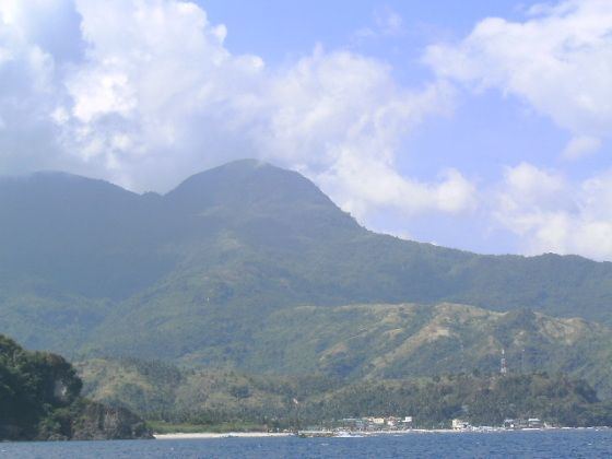
The western portion of the province is mountainous or rugged, while the east has hills and flood plains. Mount Halcon, standing 2,582 metres (8,471 ft) above sea level, is the 18th highest mountain in the country and is the province's and island's highest peak. Lake Naujan, the fifth largest lake in the country with an area of approximately 8,125 hectares (20,080 acres) of open water, is located at the northeastern part of the island and the province.
Administrative divisions
Oriental Mindoro comprises 14 municipalities, with one city, Calapan serving as the provincial capital.
Climate
Oriental Mindoro has no distinct wet or dry season. Average temperature ranges from 26 to 32 °C (79 to 90 °F). The province experiences maximum rainfall during the months of June to October. Relative humidity is registered at 81%.
Demographics
The population of Oriental Mindoro in the 2015 census was 844,059 people, with a density of 200 inhabitants per square kilometre or 520 inhabitants per square mile.
The province is largely rural, with 70% of the population engaged in agriculture and fishing and with only 30% living in urban centers. Tagalog is widely spoken in the province. Other languages spoken are Ilocano and Visayan. Dialects of the Mangyan language are Arayan, Alagnan, Buhid, Hanunoo, and Tadyawan. Because of the RORO trips coming from Caticlan, a few people from the southern part can understand Hiligaynon.
Religion
A very large portion of the population are of Roman Catholic conviction (88%). Other Christian and Islamic belief constitute most of the remaining religious affiliation in the province.
Indigenous people
The indigenous people of Oriental Mindoro are the Mangyans (Manguianes in Spanish, Mañguianes in Old Tagalog), consisting of seven distinct tribes. They occupy the interior, specially the highlands. Mangyans have inhabited the island since pre-history. They are believed to have originally traveled from Indonesia and settled down for good in the island.
Economy
Oriental Mindoro's rich and arable land is suitable for agriculture. It produces large quantities of rice, corn, coconut, vegetables and fruits like calamansi, banana, rambutan, marang or uloy, lanzones and durian. For that, Oriental Mindoro is also known as the Rice Granary and Fruit Basket of Southern Tagalog. It still is the Banana King and Calamansi King of the region. Its total agricultural area is 169,603.34 hectares (419,099.0 acres). Based on agricultural statistics, 85,244 hectares (210,640 acres) are devoted to palay production while 21,671 hectares (53,550 acres)s to coconut plantation. The province, for the past years, registered an average of 1 to 2 million cavans as surplus in rice production.
Tourist attractions
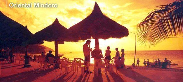
Access from Luzon via the Batangas ports mostly goes through the Verde Island Passage to reach Puerto Galera, the key entry point to Oriental Mindoro. In November 2004, Puerto Galera was voted a member of the UNESCO-affiliated ‘The Club of the Most Beautiful Bays in the World. Puerto Galera features a natural harbor which also protects ships, yachts and bancas from strong typhoons sweeping in from the Pacific.
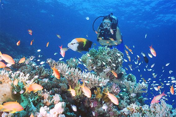
Puerto Galera, known for white sand beaches and the accompanying honky tonk bar scene on some key beaches, is known for its dive sites with a biodiversity of marine life in and around the coral reefs. Underwater rock formations and coral gardens are home to a variety of marine life, which include numerous species of nudibranch, mantis shrimp, sea anemone, moray and sea fan sea horses. The seas off the coast are host to passing dolphin pods and even the rarer whale shark, and are part of the migratory small whale route from the Visayas.
Towering 8,488 feet (2,587 m) above sea level, Mount Halcon in Baco, is a popular mountain climbing destination. Local and migratory birds allow birdwatching activities. The province is home to endemic wildlife like the tamaraw, a straight-horned water buffalo.
Other tourist destinations include:
The attraction consists of a natural spring with a swimming pool and picnic cottages. It is located in Baco, and can be reached in 45 minutes by taking a jeepney bound for the Calapan market.
The island measures 5 ha and is noted for its white sand. The place serves as the breeding place of seagulls and turtles. Corals and oysters can be found all around the area. The island is also called "Target Island" because Americans used the island for bombing practice in 1946. It is located in Baco, and can be reached in an hour through a motorized banca from the market square.
It is a rocky island, except for the area facing Buyayao Peninsula. Big snakes called "sobre kama" are found in the mountains. The water around the island is suitable for deep-sea fishing. It is located off the coast of Mansalay, and can be reached in 30 minutes by motorized banca from Mansalay market.
This is a public beach with cottages and other facilities. It is a favorite place for the local people, especially during the summer. It is located in Suqui, Calapan, and can be reached in 15 minutes by taking a tricycle from the town proper.
The place is a good spot for picnicking and swimming, especially during the summer. It is located in Pili, Pinamalayan, and can be reached by taking a jeepney to the port of Barangay Wawa, then an hour’s ride by motorized banca to the beach.
It is a secluded beach, with a 2-kilometre (1.2 mi) white sand beach. It is located in Bongol, Pinamalayan, and can be reached in two hours by boarding a Bongol-bound jeepney from the town proper of Pinamalayan and then a tricycle to the beach area.
The 423-foot (129 m) waterfalls, situated alongside the road, is actually a series of asymmetrical falls, leading to the grand one, dropping to a frothy waterbed below. The cascading waterfalls are a great attraction to passers-by. Tamaraw Falls is located in Barangay Villaflor, Puerto Galera. It can be reached in two hours by taking a jeepney bound for Barangay Villaflor from Puerto Galera, or Calapan.
An ideal place for swimming, snorkeling, and scuba diving. There are a number of resorts that offer accommodation and other travel and aqua sports facilities to both domestic and international tourists. It is located in La Laguna, Puerto Galera, and can be reached in 30 minutes from the town proper of Puerto Galera by taking a jeepney bound for La Laguna.
This area is ideal for swimming, snorkeling, and scuba diving. A cluster of nightspots abound in this area, which make it popular for evening socials. Cottages with entertainment facilities stand close to each other. Low-budget accommodations are available. It is located east of Puerto Galera, and can be reached in 15 minutes from the Puerto Galera pier by taking a jeepney or an outrigger banca.
Contrary to its name, Small La Laguna is bigger than La Laguna, and has more facilities. It has coral reefs, and its water is ideal for snorkeling and scuba diving. There are diving equipment for rent at nearby dive shops. It is located beside Sabang Beach, and can be reached in 20 minutes from the pier by taking a jeepney bound for Sabang.
This area is not as busy as the other beaches in Puerto Galera. Thus, it is an ideal site for private swimming. It is located in Puerto Galera, and can be reached in 40 minutes by taking a jeepney or an outrigger boat from the town pier.
The white sandy strips of this beach offer excellent opportunities for swimming. Resorts in this area provide entertainment facilities for tourists' greater amusement and leisure. It is located in Barangay San Isidro, Puerto Galera, and is accessible in 30 minutes from the town proper by a jeepney or a boat.
This beach is far from the busy areas of Puerto Galera; thus, it is ideal for those who seek privacy and retreat. It is located in Puerto Galera, Oriental Mindoro, and can be reached by taking a 10-minute jeepney ride from the town proper, to about one kilometer on the beach mark. The remaining distance is covered on foot.
It is a beige-colored sandy beach with cottages for rent. It is located in Roxas, Oriental Mindoro, and can be reached in 10 minutes by a banca from the pier.
Education
Higher education institutions in the province: