
Existed: 1932 – present Constructed 1932 | Length 134.4 km | |
 | ||
Oregon Route 62 is an Oregon state highway that runs between the city of Medford, and U.S. Route 97 between Chiloquin and Klamath Falls. The highway approaches Crater Lake National Park from the south, and is known as the Crater Lake Highway. While the highway is signed east-to-west, it is in reality shaped somewhat like a horseshoe; heading north-northeast from Medford, turning east as it approaches the park, and then turning south-southeast as it approaches Klamath Falls. Oregon Route 140, which intersects with OR 62 in White City, and Oregon Route 66 (which runs directly between Ashland and Klamath Falls), are more direct routes between Medford and Klamath Falls. Route 62 comprises a portion of the Volcanic Legacy Scenic Byway.
Contents
Map of OR-62, Oregon, USA
Route description
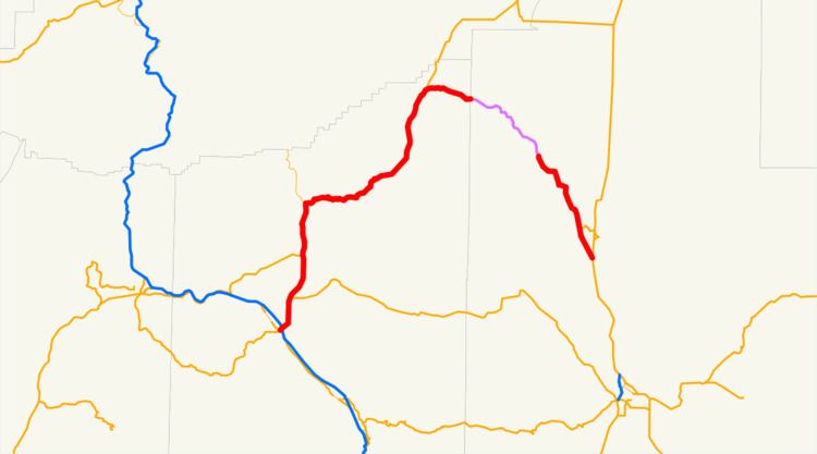
Oregon Route 62 begins (at its "western" terminus) at an intersection with Oregon Route 99 and Oregon Route 238 just north of downtown Medford. The highway heads north, crosses and intersects with Interstate 5, and continues north as an expressway. About 6 miles (10 km) north of Medford, the highway passes through White City, where it intersects with OR 140. It then heads into the Cascade foothills, intersecting with Oregon Routes 234 and 227. As it approaches the park, the highway starts heading in a more easterly direction. Just short of the park, in the community of Union Creek, the highway intersects with Oregon Route 230, which provides a north–south bypass of Crater Lake.
After the intersection with OR 230, the highway turns east. Eight miles east of Union Creek, the highway enters Crater Lake National Park, and runs through the park for 18 miles (29 km). OR 62 does not get close to the lake itself; an access road midway through the park provides a route to the rim of the lake. After the access road, the highway turns south.
West of the city of Chiloquin, the highway intersects Oregon Route 422, which provides access to Chiloquin (and US 97 northbound), and the Modoc Point Highway, which provides access to Agency Lake. South of Chiloquin, Oregon Route 62 ends at an intersection with U.S. Route 97. U.S. 97 continues south to Klamath Falls.
Oregon Route 62 is 83 miles (134 km) in length.