
Existed: 1972 – present Constructed 1972 | Length 329.9 km | |
 | ||
North end: OR 99E / OR 99W in Junction City | ||
Oregon Route 99 is a state highway that runs between the southern border of Oregon, and the city of Junction City. Oregon Route 99 was formed from parts of the former U.S. Route 99; it shares much of its route with Interstate 5, but much of it is also independent. Between Portland and Junction City, the highway is forked into two routes: Oregon Route 99E and Oregon Route 99W.
Contents
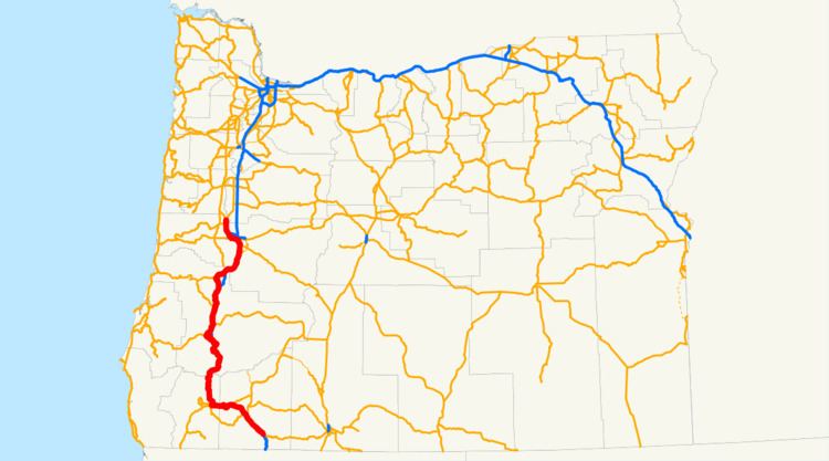
Map of OR-99, Oregon, USA
Route description
Oregon Route 99 technically starts at an interchange with Interstate 5 at exit 11, south of Ashland. There it departs from the freeway, running parallel to I-5 as it passes through the cities of Ashland (as Main Street), Talent, Phoenix, and Medford. The highway rejoins I-5 at exit 35, just Northwest of Central Point.
OR 99 departs from I-5 several more times through the mountains of southern Oregon, only to rejoin again a short distance later. Junctions are found in Gold Hill (2nd Ave), Grants Pass, between Myrtle Creek and Sutherlin (crossing I-5 in Roseburg, Oregon), through Drain and Yoncalla, and Cottage Grove and Goshen. These departures serve as business routes for I-5, as Oregon does not have or sign Interstate business routes.
When it reaches Eugene, OR 99 departs from I-5 for a final time. It heads west into downtown, along Franklin Boulevard past the University of Oregon. Downtown, OR 99 is on the 6th and 7th Avenue couplet. (Much of the section in Eugene is co-signed with either Oregon Route 126 or OR 126 Business.) West of downtown it heads north on an expressway alignment, which continues to Junction City. In Junction City, OR 99 ends, as it splits into eastern and western forks.
Highways comprised
OR 99 comprises the following named highways (see Oregon highways and routes) and roads, from south to north: