
- location in remote country - elevation 0 m (0 ft) | - elevation 55 m (180 ft) Basin area 2,056 km² | |
 | ||
- location north of Lockhart River | ||
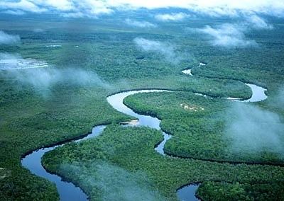
The Olive River is a river located in the Cape York Peninsula of Far North Queensland, Australia.
Map of Olive River, Shelburne QLD, Australia
The headwaters of the river rise in the Richardson Range, part of the Great Dividing Range, on the Cape York Peninsula. The river initially flows south-easterly and then veers north east and continues across the mostly uninhabited coastal plain and then white sand dunes eventually discharging into Temple Bay and the Coral Sea, north of Lockhart River. The river descends 55 metres (180 ft) over its 70-kilometre (43 mi) course.
The river has a catchment area of 2,056 square kilometres (794 sq mi) of which an area of 43 square kilometres (17 sq mi) is composed of estuarine wetlands.
The traditional owners of the area are the Wuthahti and Kuuku-ya’u peoples who maintain strong spiritual connections with their country. In 2009 the Federal Court granted native title rights over 1,980 square kilometres (760 sq mi) of land and waters north of the town of Lockhart River and north to the mouth of the Olive River, inclusive of part of the Forbes Islands National Park, the Quoin Island National Park and the Piper Islands National Park. The area was visited by HMS Paluma as part of a hydrographic survey conducted by the Admiralty in 1893 it is thought to either have been named after a Mayor of Cooktown or the characteristic tea coloured water in the river.
The riparian vegetation are home to many species only found on Cape York Peninsula including the threatened cycad plant, Cycas silvestris.