Trisha Shetty (Editor)

Ohio State Route 84

Updated on
Edit
Like
Comment
Share on FacebookTweet on TwitterShare on LinkedInShare on Reddit
Existed:
  
1924 – present

East end:
  
PA 226 near Conneaut

Constructed
  
1924

West end:
  
US 6 / US 20 in Euclid

Length
  
101.9 km

Ohio State Route 84

Counties
  
Cuyahoga County, Ohio, Lake County, Ohio, Ashtabula County, Ohio

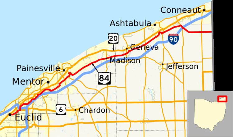
State Route 84 (SR 84) is an east–west state highway in the northeastern portion of the U.S. state of Ohio. Its western terminus is along US 6 at US 20 in Euclid, and its eastern terminus is at the Pennsylvania state line about 10 miles (16 km) south-southeast of Conneaut; Pennsylvania Route 226 continues eastward.

A portion of SR 84 runs along the historic Johnnycake Ridge Road.

History

  • 1923 – Original route established; originally routed from 1-mile (1.6 km) south of Madison to 2 miles (3.2 km) west of Andover along the current alignment of State Route 307 from 1-mile (1.6 km) south of Madison to Dorset, and a currently unnumbered road from Dorset to West Andover.
  • 1926 – Extended to Willoughby Hills along a previously unnumbered road.
  • 1931 – Truncated at Dorset; Dorset to West Andover decertified.
  • 1935 – Rerouted from Madison to Ashtabula along the previous State Route 307 alignment (which was unnumbered before 1933); former alignment from south of Madison to Dorset certified as State Route 307.
  • 1938 – Extended to Pennsylvania state line along the former alignment of State Route 83 from Ashtabula to Kelloggsville (which was unnumbered before 1926), and along a previously unnumbered road from Kelloggsville to the state line.
  • References

    Ohio State Route 84 Wikipedia