
Existed: 1938 – present Constructed 1938 | Length 98.52 km | |
 | ||
Counties | ||
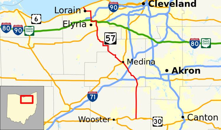
State Route 57 (SR 57) is a north–south state highway in northeast Ohio. SR 57 runs from U.S. Route 30 (US 30) in Riceland to US 6 in Lorain, a distance of 61.2 miles (98.5 km).
Contents
Map of OH-57, Ohio, USA
Route description
SR 57 begins as a city street in downtown Lorain. The four-lane highway travels towards Interstate 90 (I-90). The one mile (1.6 km) stretch of the highway between I-90 and the Ohio Turnpike (I-80) in the city of Elyria is flanked on both sides with hotels, businesses and the Midway Mall. South of the Ohio Turnpike, the highway remains four lanes wide and continues south (concurrent with SR 113, SR 301, and US 20) through Elyria. The highway connects with SR 10 just south of Elyria via highway interchange and separates from SR 301 and US 20. South of SR 10 the highway retains four lanes to its intersection with SR 82 where it narrows to a two-lane highway through the remainder of Lorain County and Medina County.
As SR 57 traverses the rural communities of Medina County, it takes more of an east-southeast track as it joins and separates with SR 83 and SR 303. It then merges with SR 18 as it heads towards the city of Medina. SR 57 passes through Medina's town square and heads southeast as Wadsworth Road towards I-71 where it travels over the six-lane expressway en route to its southern terminus. SR 57 continues its path south passing through rural communities in Wayne County. It intersects with I-76 near Wadsworth and continues south past the Wadsworth Municipal Airport, through Orrville on its way to the terminus in Riceland where it meets US 30 in Wayne County.
History
Prior to the construction of the SR 2/Ohio Turnpike connector around 1976, I-90 traffic had to use SR 57 to access the Turnpike. In 2003 the loop from SR 57 southbound to I-90/SR 2 eastbound in this interchange was removed and replaced by a left turn to simplify traffic movements on SR 57, and the opposite loop had been removed by 2004 to make it a six-ramp partial cloverleaf interchange.
Rebuilding and widening program
The improvement of the SR 57 corridor between the Ohio Turnpike and I-90 in Elyria is a long awaited project to improve safety and reduce congestion in this heavily commercial area. This stretch of SR 57 contains a disorganized cluster of roads and exits and has been said to be a high-crash zone, according to city and Ohio Department of Transportation District 3 officials. This project will modify the existing SR 57 interchange with I-90 in Elyria as well as remove the existing 49th Street bridge over SR 58. SR 57 will be widened to six lanes between the Ohio Turnpike and I-90, and Midway Mall Boulevard will also be widened. The SR 57 and I-90 interchange will be converted to a full diamond interchange with signals.