
OS grid reference NS852969 Sovereign state United Kingdom Postcode district FK11 Population 2,084 (2011) | Post town Menstrie Dialling code +44 (0) 1259 Local time Sunday 2:04 AM Lieutenancy area Clackmannanshire | |
 | ||
Weather 8°C, Wind SW at 21 km/h, 100% Humidity UK parliament constituency | ||
Menstrie (Scottish Gaelic: Meanstraidh) is a village in the county of Clackmannanshire in Scotland. It is about 5 miles (8 kilometres) east-north-east of Stirling and is one of a string of towns that, because of their location at the base of the Ochil Hills, are collectively referred to as the Hillfoots Villages or simply The Hillfoots.
Contents
- Map of Menstrie UK
- Physical geography
- Facilities
- Transport links
- Industry and population
- Commercial forestry
- Recreation
- Architecture and housing
- References
Map of Menstrie, UK
Physical geography
Menstrie stands on the carse or flood plain of the River Devon, between 10 and 20 metres altitude above sea level. It is roughly astride the Ochil Fault whose movement gave rise to the dramatic southern scarp of the Ochils but which is now almost quiescent.
Two of the most westerly summits of the Ochil Hills, Dumyat and Myreton Hill, rise steeply to the north of the village to reach about 400m altitude. These two hills are divided by Menstrie Glen, from which the small watercourse of Menstrie Burn emerges and runs through the village. About a kilometre to the south of Menstrie, the burn joins the River Devon which in turn meets the River Forth at Cambus.
The Menstrie Burn, though generally tranquil, drains a catchment area (Menstrie Glen) of about 14 km2 in the Ochil Hills and occasionally experiences flash floods. On 29 August 2012, the burn overflowed its banks and 38 elderly residents of Menstrie House had to be evacuated to other care homes within the region. No-one was hurt. The Community Centre and some nearby roads and houses were also flooded though no residents needed evacuation. The A91 road was closed for some hours while structural engineers checked the integrity of the bridges over the burn. Clackmannanshire Council commissioned a consultants' report on the flood event and has made the summary available to the public in PDF format.
Facilities
The village has two general stores (one containing the Post Office), a pharmacy, a pub (The Holly Tree) and a petrol station. Menstrie also has a library, small sports centre, public park, primary school, a residential establishment for older people and two churches; one being Menstrie Parish Church (Church of Scotland) and the other being of the United Free Church of Scotland.
Transport links
Menstrie is on the A91 road from Stirling to St Andrews. It used to be served by Menstrie & Glenochil Railway Station on the Alva Line until that closed. Bus services run to Stirling via Stirling University, to Alloa via Alva and Tillicoultry or via Tullibody, and less frequently to St Andrews. Beginning in late 2010, bus services also run to Clackmannan and to Forth Valley Royal Hospital near Falkirk via Alloa.
Industry and population
A conspicuous zig-zag roadway up the scarp face of Myreton Hill, nowadays used by the local sheep farmer for access to his livestock, was originally built during the Napoleonic Wars for access to some mine workings, which produced calcite. However, the volume of material mined was rather small in proportion to the effort needed to build the road, so the venture is unlikely to have been economic. There seems to be no record of why calcite was considered to be sufficiently valuable to have justified the considerable effort.
The occupants of Menstrie once processed wool from sheep farmed on the Ochils. In 1800, businessmen from Tullibody set up a carding and spinning mill on the east side of the Menstrie Burn to exploit its soft water and power, absent from their own village.
In the early 19th century a straight road was built on the flat ground of the carse or floodplain to by-pass the old Hillfoots Road and improve the transport of goods to and from the Hillfoots villages. Menstrie's Long Row and Ochil Road lie on the old route along the foot of the hills. The new road, now the A91, became a focus for construction of churches, houses, mills and shops.
By the mid-19th century, the Elmbank and Forthvale mills were in business on either side of the Menstrie Burn.
In 1841, Menstrie's population was about 500 but had increased to more than 900 by 1881.
In the 1860s a company, which included the owners of local mills and a distillery, financed a branch railway line through Menstrie to a terminus in Alva. This joined the old North British Railway (N.B.R.) line between Alloa and Stirling at Cambus. Menstrie had its own passenger station at the North end of Tullibody Road. Practically nothing of the station remains and the railway branch line, which continued to carry freight after the Beeching Axe, fell into disuse during the mid-1980s in favour of road transport.
The Glenochil Distillery had opened in the middle 18th century on the site of the Doll Farm to the east of the village, beside the Dams Burn. Manufacturing has continued on this site for more than 250 years though production of whisky stopped around 1930. Yeast, initially a by-product of whisky fermentation, had gradually become the main product and went for manufacture of whisky and bread. Soft water, locally available, is still useful. An extensive bonded warehouse area remains for storage of whisky as it matures in barrels before bottling, while bakers' yeast has given way to fermentation products derived from yeast.
The whisky and yeast businesses are now operated by separate companies, namely Diageo, (successors to Distillers Company) and Kerry Group. The latter conducts product development as well as manufacturing at the Menstrie site.
The Forthvale Mill no longer stands but the Elmbank Mill, having been used for some years as offices by the Water Board, now houses small businesses.
A furniture factory, The Charrier, stood near the Menstrie Burn but was destroyed by fire in about 1968. A street nearby now bears its name.
In the mid-20th Century, Menstrie (pop. 1200 - 1300) was home to families whose menfolk worked the Clackmannanshire Coalfield and other mines in Central Scotland.
As the mining and textile industries have declined, Menstrie has become a commuter dormitory, spreading over the adjacent farmland. At the Censuses in 1991, 2001 and 2011, Menstrie's population was 2274, 2083 and 2804 respectively.
In 2014, Menstrie was rated one of the most attractive postcode areas to live in Scotland.
Commercial forestry
A forestry company, UPM Tilhill, has published plans to plant commercial woodland in the Ochil Hills above Menstrie on the eastern and northern flanks of Menstrie Glen. This would affect recreational use and customary access routes, though UPM have made alterations to accommodate some concerns.
Forestry operations, including movement of heavy machinery and extraction of harvested timber would take place via widened roads and strengthened bridges on Sheriffmuir rather than through Menstrie, according to the plan.
The plan includes an area, on Myreton Hill, of broadleaf woodland. This would be the main effect seen from Menstrie and nearby Hillfoots villages. The conifer planting would, however, be visible from further afield; for instance Stirling Castle, National Wallace Monument and Tullibody.
More information about the plans is available on Menstrie Community Council's web site.
Planting had begun by early 2015.
Recreation
Menstrie stands on The Hillfoots Way, a walking route that follows much of the old King's Highway. The Hillfoots Way goes from Logie Old Kirk in the west to Muckhart in the east, along the foot of the Ochils. The King's Highway (via regia in Latin) is mentioned in charters for Cambuskenneth Abbey that date to the 1300s and may have been used for royal progresses between Stirling Castle and Falkland Palace in the 16th century.
Menstrie has a Scout Group, established in 1908, and a bowling club.
Menstrie and the nearby Blairlogie are access points to Dumyat, a peak in the Ochil Hills popular with hillwalkers. Menstrie also provides access to Myreton Hill, used by paragliders.
The disused railway line served as an unofficial walking route to Tullibody over the bridge across the River Devon. In October 2007 Clackmannanshire Council published a map which designated part of the railway line, by then heavily overgrown, as an Aspirational Core Path linking Menstrie and Cambus. By February 2010 the branch line had been sold by BRB (Residuary) Limited and by March 2011 the rails and sleepers had all been removed. Work on the path was completed by April 2012, as scheduled. The path now forms part of National Cycle Network Route 768.
"Fox Boy", a work by the sculptor Andy Scott, stands in the centre of Menstrie in Midtown Gardens (now named the "Nova Scotia Gardens" to commemorate the village's historical connection). The sculpture combines references to the water wheels that once powered industry in Menstrie, a pet fox kept by a Menstrie child years ago, and the buzzards that frequent the skies over the village.
Architecture and housing
Menstrie Castle was the birthplace of Sir William Alexander, James VI’s Chartered Lieutenant for the Plantation of Nova Scotia. Despite its name, it is described as a "three-storey castellated house", and lacks many fortified features, standing as it does on low ground and constructed at a time of relative national calm. The building is now residential and has won a Civic Trust award.
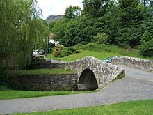
The old (pre-19th century) bridge over the Menstrie Burn is listed by The Royal Commission on the Ancient and Historical Monuments of Scotland under number 219364.
In 1874, James Johnstone, one of the partners in the Elmbank Mill, had built for himself the Scottish baronial-style Broom Hall on the lower slope of Myreton Hill. It was burned out in the 1940s and stood as an abandoned shell until 1985 when it was converted into a nursing home. It has since been refurbished as a restaurant.
The war memorial was erected in 1922 and lists those killed in the World Wars. The bulk of those killed in the First World War were in the 7th Battalion Argyll and Sutherland Highlanders. In June 2016 a plaque was unveiled at the war memorial remembering the Polish soldiers who were stationed in the village.
As a commuter town Menstrie has undergone a period of expansion since 2000, with new housing built to the west and south of the village. The firm responsible for maintenance of common areas around the new housing is currently (spring 2012) in dispute with an association of residents. The residents complain that: the maintenance work fails to meet standards stated in the deeds; that the charges are excessive; and that the company has resorted to excessively heavy-handed methods to extract payment, accusations the company rejects.
In December 2009, Clackmannanshire Council announced an alteration to the local development plan for housing land. This allowed for construction of 175 new housing units, including 36 termed 'affordable', to the south-east of the village. The Council subsequently modified the plan as recommended by a Reporter appointed by Scottish Ministers. In the absence of further directions from the ministers, the council formally adopted the modified plan in the autumn of 2011. Among other stipulations and guidelines the modified plan as adopted allowed for 175 housing units, 43 affordable; and required a detailed Flood Risk Assessment to determine ground conditions and water management needs on and for the site.
An application for construction of 84 houses on the site was made on 08 April 2013. Among the documents relating to the application, one from SEPA on 30 Oct 2013 stated "... we would not support the proposal to include additional properties behind the embankment as we would not consider this area to be outwith the 1:200 year flood extent." The application was subsequently removed from the planning register.