
Established 13th century Highest elevation 1,138 m (3,734 ft) | County Nowy Targ County Town rights 1346 Population 33,493 (2006) | |
 | ||
Gmina Nowy Targ (urban gmina) Weather 5°C, Wind W at 10 km/h, 88% Humidity Points of interest Muzeum Podhalańskie w Nowym, Pływalnia Miejska w Nowym T, Bór na Czerwonem, Zadział sc Wyciąg narciarski, Izba Zimnej Wojny i Socjalizmu | ||
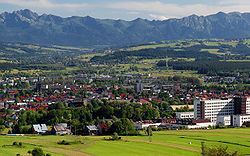
Nowy Targ [ˈnɔvɨ ˈtark] (Latin: Novum Forum, Slovak: Nový Targ, German: Neumarkt) is a town in southern Poland with 34,000 inhabitants (2006). It is the historical capital of the Podhale region. The town is situated in a valley beneath the Gorce Mountains featuring Gorce National Park established in 1981, at the confluence of rivers Biały and Czarny Dunajec. Administratively, it is in Nowy Targ County in the Lesser Poland Voivodeship. It was previously in Nowy Sącz Voivodeship (1975–1998).
Contents
- Map of Nowy Targ Poland
- Timeline of town history
- Geography
- Climate
- Culture
- Museums
- Cinemas
- St Anna Church
- St Catherine Church
- Education
- Ice hockey
- Floorball
- Nature reserves
- Twin towns Sister cities
- References
Map of Nowy Targ, Poland
Timeline of town history
Geography
Nowy Targ is located in the heart of Polish highlands at the altitude of 585–850 m above sea level (AMSL); latitude 49°28' N, longitude 20°01' E. Distance to the main urban agglomerations in Poland is: Warsaw – 376 km (234 mi), Łódź – 348 km (216 mi), Kraków – 84 km (52 mi), Gdańsk – 690 km (429 mi), Wrocław – 346 km (215 mi), Katowice – 157 km (98 mi), Kielce – 200 km (124 mi), Rzeszów – 214 km (133 mi), Szczecin – 727 km (452 mi), Białystok - 574 km (357 mi), Poznań – 475 km (295 mi), Częstochowa – 226 km (140 mi), Słupsk – 759 km (472 mi).
Climate
Due to its altitude, Nowy Targ is one of the coldest cities in Poland together with Suwałki and Zakopane. Winter usually lasts from late November to early April and between 90 and 110 days a year there is a snow cover. Air frost has been measured in every month of the year except for July. Summers are mild with occasional thunderstorms and high temperatures between 17 and 25 degrees Celsius. Hot days (over 30 °C (86 °F)) are rare, only occurring twice annually on average. Precipitation is heavy for Polish standards, varying between 900 millimetres at the airport and 1100 millimetres in Kowaniec to around 1350 millimetres on Bukowina Miejska, the highest part of the city. The growing season equally varies between on average 150 days on Bukowina Miejska to around 200 days in the lower parts of the city. Nowy Targ is in the AHS Heat Zones 1-2 and USDA Hardiness Zone 4a to 5b, depending on the location.
According to the Köppen climate classification, Nowy Targ straddles the border of the Warm Summer Continental (Dfb) and Subarctic (Dfc) climates, with most of the city falling in the Dfb group. The Dfc climate is only found above 800 metres of elevation within Nowy Targ.
Culture
Museums
Cinemas
St. Anna Church
Wooden church overseeing the city cemetery. Its origins date to the 15th century, although local legends describe it as founded in 1219.
Initially built in a gothic style, it was later repaired and rebuilt featuring, among others, a baroque altar piece and paintings, a rococo pulpit, and 18th-century organ and bell tower.
St. Catherine Church
Dedicated to St. Catherine of Alexandria, the church was built in 1346 by King Casimir the Great. It is the oldest existing church of the Podhale region.
The church has been damaged by numerous fires and military attacks, and subsequently rebuilt and renovated. The interior retains its baroque character, especially in the altar and side chapels, although numerous pieces are replicas of wooden originals lost to fire. A painting of St. Catherine from 1892 dominates the main altar.
Education
Ice hockey
Floorball
Nature reserves
Twin towns — Sister cities
Nowy Targ is twinned with: