
Formed November 8, 2014 Damage Unknown Total fatalities At least 28 | Dissipated November 23, 2014 Dates 8 Nov 2014 – 23 Nov 2014 | |
 | ||
Similar December 2014 North American, November 13–21 - 2014 Nort, Mid‑December 2007 North American, Groundhog Day gale of 1976, Great Storm of 1975 | ||
The November 2014 North American cold wave was an extreme weather event that occurred across most of Canada and the contiguous United States, including parts of the Western United States up to western California. One of the first events of the winter, the cold wave was caused by the northward movement of an extremely powerful bomb cyclone associated with Typhoon Nuri's remnant, which shifted the jet stream far northward, creating an omega block pattern. This allowed a piece of the polar vortex to advance southward into the Central and Eastern United States, bringing record-cold temperatures to much of the region. In contrast, Alaska experienced above-average temperatures.
Contents
This was the worst cold wave that the North American region had experienced since an earlier cold wave in early 2014. The cold wave was expected to last for a few weeks, extending at least until American Thanksgiving. Although the Omega Block broke down on November 20, due to a powerful storm moving into the Gulf of Alaska, frigid conditions continued to persist across much of the United States. There was also concern among some meteorologists that another cold wave or abnormally cold trend might persist throughout the winter of 2014–15, the chances of which were "above average." On November 23, a warming trend primarily in the Eastern United States brought an end to the cold wave; however, below-average temperatures were forecast to return to the Midwest by November 24. Despite the development of a second cold wave, it ended on December 6, when a ridge of high pressure brought above-average temperatures to the region, especially in the Central United States.
Origins
On November 8, the northward movement of a cyclone associated with Typhoon Nuri shifted the jet stream far to the north, creating an omega block pattern, which allowed a fragment of the polar vortex to descend from Arctic region into lower Canada and the Eastern United States, affecting up to 200 million people with colder-than-normal temperatures and early snowstorms. Although the Omega block broke down on November 20, a powerful storm brought more frigid temperatures. The wave ended on December 6 when an area of high pressure moved in.
Meteorologists also predicted that the winter of 2014–15 would be abnormally cold across the Eastern United States, due to early snowfall in Siberia, and a weak but developing El Niño, which are both factors in erratic jet stream behavior that could lead to an abnormally cold winter.
United States
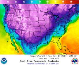
November 18 was the coldest November morning since 1976 with a national average temperature of 19.4 °F (−7.0 °C) and below freezing temperatures reported in all 50 states. Some U.S. locations had temperatures 45 °F (25 °C) below normal.
On November 13, Casper, Wyoming had its lowest temperature ever recorded in November, with a record low of −27 °F (−33 °C), and Denver, Colorado had a low of −14 °F (−26 °C), the second coldest ever recorded for that month. On November 18, Detroit tied a record of 11 °F (−12 °C), first set in 1880. Jacksonville, Florida reached 24 °F (−4 °C) on November 20, 2014, breaking a record set in 1873.
The cold wave brought an end to the navigation season on the upper Mississippi River, the earliest closing since records began in 1969.
United States
A severe and persistent lake-effect snow event hit the Great Lakes snowbelt regions, triggered by a winter storm that emerged from Canada, to the north of the Midwest.
On November 10, St. Cloud, Minnesota had the biggest snowfall ever in November with 13.2 inches (34 cm). By the next day, Ishpeming, Michigan had 24.5 inches (62 cm), the most of any location.
In Buffalo, New York, another winter storm triggered a strong lake-effect band, which impacted the city and its immediate southern suburbs from November 17–19, 2014, with a second wave hitting November 20 before shifting southward and weakening. As much as 65 inches fell in Cheektowaga. Snow fell at rates as high as five inches per hour. However, nearby regions of Buffalo only received between one and six inches from the storm. Once the band dissipated, the risk of flooding became a significant concern, as temperatures were forecast to rise sharply and rain was forecast to enter the area beginning November 23, causing the snowpack to melt rapidly.
South Bend, Indiana received 12.3 inches on November 13, breaking its old record for that day of five inches.
Snow depths of greater than 24 inches where reported in numerous location across the Upper Peninsula of Michigan. with 42.5 inches reported near Ishpeming between November 10–12. Gaylord and Sault Ste. Marie, Michigan had each reported over 50 inches of snow in November. Allendale in west Michigan received 20.4 inches with 17 inches in East Grand Rapids.
On November 23, the formation of a ridge of high pressure across the Southeastern United States forced the polar vortex fragment over the Eastern United States to retreat back to Canada, allowing a warming trend across much of the Midwest and the Eastern United States. However, this same warming trend brought concerns that the resulting snowmelt and incoming rain may cause floods in the region.
United States
Sustained winds of 110 km/h (70 mph) with gusts to 156 km/h (97 mph) were recorded on the island of Shemya. Only minor damage was reported on the island which houses a United States Air Force installation. On November 12, a winter storm in the Great Lakes region killed four people in Minnesota. On November 17, another winter storm caused the deaths of at least 11 people in traffic-related accidents. By November 19, another seven people had died in western New York from the cold temperatures brought by that same winter storm. On November 20, another person died from the cold. On November 22, the death toll from the November 13–21 winter storm increased to 13 fatalities (not including 11 earlier traffic accidents).
Because of weather-related difficulties in the Buffalo area, many sporting events were postponed, canceled, or moved.