
Topo map USGS Mount Katmai B-4 Volcanic arc/belt Aleutian Arc Last eruption 1912 Parent range Aleutian Range | Elevation 841 m Mountain range Aleutian Range | |
 | ||
Similar Mount Katmai, Mount Mageik, Mount Veniaminof, Trident Volcano, Mount Pinatubo | ||
Alaska peninsula novarupta katmai eruptions dr arif herekar
Novarupta (meaning "newly erupted" in Latin) is a volcano that was created in 1912, located on the Alaska Peninsula in Katmai National Park and Preserve, about 290 miles (470 km) southwest of Anchorage. Formed during the largest volcanic eruption of the 20th century, Novarupta released 30 times the volume of magma of the 1980 eruption of Mount St. Helens.
Contents
- Alaska peninsula novarupta katmai eruptions dr arif herekar
- Map of Novarupta Alaska USA
- Novarupta trailer 01
- Eruption of 1912
- Valley of Ten Thousand Smokes
- Katmai National Park
- References
Map of Novarupta, Alaska, USA
Novarupta trailer 01
Eruption of 1912
The eruption of Novarupta within the Aleutian Range began on June 6, 1912, and culminated in a series of violent eruptions from the original Novarupta volcano. Rated a 6 on the Volcanic Explosivity Index, the 60-hour-long eruption expelled 13 to 15 cubic kilometers (3.1 to 3.6 cu mi) of ash, 30 times as much as the 1980 eruption of Mount St. Helens. The erupted magma of rhyolitic, dacitic, and andesitic composition resulted in more than 17 cubic kilometers (4.1 cu mi) of air fall tuff and approximately 11 cubic kilometers (2.6 cu mi) of pyroclastic ash-flow tuff. During the 20th century, only the 1991 eruption of Mt. Pinatubo in the Philippines was of a similar magnitude; Pinatubo ejected 11 cubic kilometers (2.6 cu mi) of tephra. At least two larger eruptions occurred in the 19th century: the 1815 eruption of Tambora (150 km3 (36.0 cu mi) of tephra) and the 1883 eruption of Indonesia's Krakatoa (20 km3 (4.8 cu mi) of tephra).
The Novarupta eruption occurred about 2.5 miles from the peak of Mount Katmai Volcano and 4,000 feet below the post-eruption Mount Katmai summit. During the eruption a large quantity of magma erupted from beneath the Mount Katmai area, resulting in the formation of a 2-kilometer (1.2 mi) wide, funnel-shaped vent and the collapse of Mount Katmai's summit, creating a 600-meter (2,000 ft) deep, 3 by 4 km (1.9 by 2.5 mi) caldera.
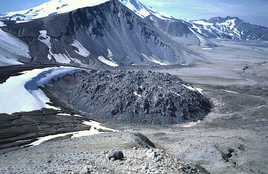
The eruption ended with the extrusion of a lava dome of rhyolite that plugged the vent. The 295-foot (90 m) high and 1,180-foot (360 m) wide dome and the caldera it created form what is now referred to as Novarupta.
Despite the magnitude of the eruption, no deaths directly resulted.
The eruption is said to have had an effect on the level of the Nile River.
Valley of Ten Thousand Smokes
Pyroclastic ash flow from the eruption formed the Valley of Ten Thousand Smokes, named by botanist Robert F. Griggs, who explored the volcano's aftermath for the National Geographic Society in 1916.
The eruption forming the Valley of Ten Thousand Smokes is one of the few in recorded history to have produced welded tuff, producing numerous fumaroles that persisted for 15 years.
Katmai National Park
Established as a National Park & Preserve in 1980, Katmai is located on the Alaska Peninsula, across from Kodiak Island, with headquarters in nearby King Salmon, about 290 mi (470 km) southwest of Anchorage. The area was originally designated a National Monument in 1918 to protect the area around the 1912 eruption of Novarupta and the 40-square-mile (104 km2), 100-to-700-foot (30 to 210 m) deep, pyroclastic flow of the Valley of Ten Thousand Smokes.