
Population 4,393 (2011 census) Postcode(s) 2121 Founded 1899 | Established 1899 Area 230 ha Postal code 2121 | |
 | ||
Location 19 km (12 mi) from Sydney CBD | ||
North Epping is a suburb of Sydney, in the state of New South Wales, Australia 19 kilometres north-west of the Sydney central business district in the local government area of Hornsby Shire. North Epping is in the Northern Suburbs region. Epping is a separate suburb to the south, which shares the postcode of 2121.
Contents
- Map of North Epping NSW 2121 Australia
- Aboriginal culture
- European settlement
- Lin family murder
- Becoming a separate suburb
- Commercial area
- Transport
- Demographics
- Politics
- References
Map of North Epping NSW 2121, Australia
North Epping is a leafy suburb, surrounded by bushland of the upper section of Lane Cove National Park. There are many walking trails, including the Great North Walk. One of the well known landmarks is Whale Rock.
Aboriginal culture
The Wallumedegal Aboriginal tribe lived in the area between the Lane Cove River and Parramatta River, which was known as Walumetta.
European settlement
In 1792 Governor Phillip began the granting of parcels of lands to marines, and the area was referred to on Phillip's maps as the Field of Mars, named after the Roman Field of Mars probably because of the military link. It contained the area of what is now Epping and North Epping. The name Epping is derived from Epping Forest in Essex, England.
Lin family murder
In the early hours of 18 July 2009, the Lin family, consisting of Min Lin, Yun Li Lin, her sister Yun Lin, and the parents' two children Henry and Terry Lin, were all murdered at their home on Boundary Road, North Epping. Robert Xie was arrested at his home in North Epping on 5 May 2011 at 9.00am for killing the family. He is currently on trial. Brenda Lin, the last living member of the family, lived with the alleged killer and his wife for 22 months. A funeral was held for the family at Sydney Olympic Park, New South Wales on 8 August 2009.
Becoming a separate suburb
North Epping was split off from Epping as a separate suburb on 1 December 1995.
Commercial area
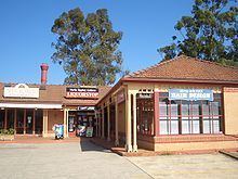
North Epping has a small shopping centre located on the corner of Roma Street and Malton Road. It features a number of specialty shops, cafes and restaurants. North Epping also has a small school - Epping North Public School. North Epping has many parks, many community areas and gatherings.
Transport
The M2 Hills Motorway runs along the southern border to the Sydney CBD. North Epping is connected to adjacent Epping by a single road, Norfolk Road. Norfolk Road runs south towards Epping Road, a major arterial road in the area that runs east to the Pacific Highway. Almost all areas of the suburb are serviced by Sydney Buses route 295 (Macquarie Centre to North Epping). The route is a loop and only goes clockwise around the edge of the suburb- the only place where it runs in both directions is Norfolk road south of Grayson street, towards Epping railway station.
At the 2011 census, 22.1% of employed people travelled to work on public transport and 56.1% by car (either as driver or as passenger).
Demographics
At the 2011 census, North Epping recorded a population of 4,393. Of these:
Politics
North Epping is under the municipal authority of Ward C in the Hornsby Shire Council, is part of the federal electorate of Bennelong and State electorate of Epping.