
Population 20,227 (2011 census) Postcode(s) 2121 Postal code 2121 | Established 1899 Founded 1899 | |
 | ||
Lga City of Parramatta Council | ||
Epping is a suburb of Sydney, in the state of New South Wales, Australia 18 kilometres north-west of the Sydney central business district in the local government area of the City of Parramatta. It is in the Northern Suburbs and Greater Western Sydney region.
Contents
- Map of Epping NSW 2121 Australia
- History
- Commercial area
- Redevelopment as Urban Renewal Area
- Transport
- Community facilities
- Churches
- Schools
- Demographics
- Politics
- References
Map of Epping NSW 2121, Australia
History
The Wallumedegal Aboriginal tribe lived in the area between the Lane Cove River and Parramatta River. In 1792, Governor Phillip began the granting of parcels of lands to marines, and the area was referred to on Phillip's maps as the Field of Mars, Mars being the Roman god of War. It contained the area of what is now Epping, along with the surrounding suburbs of Ryde and Marsfield.
Epping railway station was opened on 17 September 1886, originally named "Field of Mars", and quickly renamed to "Carlingford" on 5 April 1887. The Post Office was opened on 16 October 1889, originally named "East Carlingford".
In 1899 the suburb name of Epping was adopted following the suggestion by a local landowner William Midson (1849–1924), after a town near Epping Forest in Essex, where his father was born. At this time, the names of the Post Office and the railway station were both changed to Epping.
The Seven Network had television production studios in Epping until 2009. The site is now occupied by residential apartments.
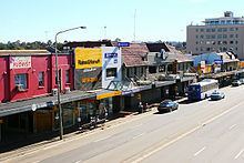
Commercial area
Epping features a shopping centre close to Epping railway station. The centre includes a large Coles supermarket on Rawson Street, and many small businesses including newsagencies, pharmacies, Asian grocers and many restaurants. Other commercial and light industrial developments are also located in the surrounding area.
The Epping RSL Club is a popular venue, which attracts many people including students from the nearby Macquarie University. Epping also has a pub (the Epping Hotel) with its own nightclub, Tracks.
Redevelopment as "Urban Renewal Area"
A major re-development of the Epping Town Centre is planned as part of the NSW government's "Urban Renewal Area" programme (originally called the "Urban Activation Precincts" programme). The changes to zoning for this programme cover 54 hectares, including provision for building heights of 8 to 22 storeys for mixed commercial and residential use within a 400-metre radius of the railway station, and about 3,750 additional homes within 800 metres of it. These zoning changes were finalized and approved in March 2014, although residents have expressed concerns about issues including traffic management, lack of parking, storm water drainage, and access to schools.
The first major project under this programme was scheduled to be Grocon's amalgamation of four lots at 30-42 Oxford Street, acquired in September 2015 for a cost of $56 million. Plans for a 16-storey development of more than 250 apartments for a total value of more than $300 million were lodged with the council. However, in early 2016 they sold the blocks again.
Transport
Epping railway station is a junction station on the North Shore, Northern & Western Line and the Epping to Chatswood railway line of the Sydney Trains network. It will also be a junction station on the new rapid transit Sydney Metro Northwest when that line is completed.
Epping is also well-serviced by bus facilities by Sydney Buses and Hillsbus. The M2 Hills Motorway runs along the northern border to the Sydney CBD. Epping Road is a major arterial road in the area that runs east from the railway station to the Pacific Highway.
In spite of the range of public transport options, the 2011 census found that only 31% of employed people travelled to work on public transport, compared to 51% who travelled by car (either as driver or as passenger).
Community facilities
Epping is well served with community facilities, provided by the councils or other organizations. These include:
Some schools and churches also have halls and other facilities that can be made available for community uses.
Churches
Schools
Formerly the American International School of Sydney was located here.
Demographics
According to the Australian Bureau of Statistics 2011 Census, Epping had a population of 20,227, of whom 9,883 (48.9%) were male and 10,344 (51.1%) were female. Approximately half (49.5%) of residents living in Epping were Australian born and the majority of its migrant residents hail from China (11.7%), South Korea (6.6%), Hong Kong (6.1%), India (4.6%) and England (2.3%).
The age distribution is quite typical of the whole country: the median age of people in Epping was 38 years (national median is 37). Children aged under 15 years made up 16.3% of the population (19.3% nationally) and people aged 65 years and over made up 13.2% of the population (14.0% nationally).
Epping is also known to be a more affluent suburb in its region, as evidenced by its higher median house prices compared to neighbouring suburbs, and the high proportion of professionals (39.7%) who reside in Epping (nearly double the Sydney average of 21.3%). Average weekly household income was $1,683, compared to the national average of $1,234.
More than three-quarters (76.8%) of private dwellings were family households, 19.3% were single person households and 4.0% were group households. Stand-alone houses accounted for 62.6% of dwellings, while 27.9% were flats, units or apartments and 9.3% were semi-detached. The average household size was 2.8 people.
The most commonly reported religious affiliation in the 2011 Census was "no religion" (26.8%), followed by Roman Catholic (19.3%), Anglican (12.9%), Presbyterian and Reformed (6.9%) and Buddhism (5.2%). In the ten years from 2001 to 2011, the Census shows that the largest change in religion was the number of people who were not affiliated with any religion, which increased from 16.3% to 26.8% of the population. There were also increases in Buddhism (4.2% to 5.3%) and Hinduism (2.9% to 4.9%). The combined number of people following all Christian denominations dropped from 64.7% to 55.0%.
Politics
At a local government level, Epping lies solely within the City of Parramatta Local Government Area. Until May 2016, it was divided between three different local government areas: the Hornsby Shire, the City of Parramatta, and a smaller area in the City of Ryde‹See TfD›. This changed under the 2016 NSW State Government's "Stronger Councils" amalgamation scheme.
At a state level, Epping is mostly represented by the electoral district of Epping, with a small area on the southern edge of Chesterfield Road that is within the Electoral district of Ryde.
At a federal level, Epping falls in the Division of Bennelong.