
Admin HQ Barnstaple University Petroc | Constituent country England Area 1,086 km² | |
 | ||
Status Non-metropolitan district Points of interest Destinations Exmoor, Woolacombe, Barnstaple, Ilfracombe, Croyde | ||
North Devon is a local government district in Devon, England. Its council is based in Barnstaple. Other towns and villages in the North Devon District include Braunton, Fremington, Ilfracombe, Instow, South Molton, Lynton and Lynmouth. The district was formed on 1 April 1974 as a merger of the Barnstaple municipal borough, the Ilfracombe and Lynton urban districts, and the Barnstaple and South Molton rural districts.
Contents
- Map of North Devon District UK
- Visit north devon
- Population
- Governance
- Transport
- Economy
- Barnstaple
- References
Map of North Devon District, UK
The wider geographic area of North Devon is divided between North Devon District and the district of Torridge, based in Bideford.
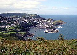
Visit north devon
Population
North Devon is popular with retired people. The 2011 census showed that 18% of residents were aged 15 years and under, 60% were aged 16–64 and 23% were aged 65 and over. This compares to the 20% of the population who were aged 65 and over when the 2001 census was taken. For comparison, the same age distributions across England were 19%, 64% and 17% respectively. Life expectancy for men, at 77.7, is close to the English average. Female life expectancy is good at 83.1, around 1 year above the English average. There is a gap of 6 years in the life expectancy of men in the least deprived fifth of wards and the most deprived fifth. The region has one of the most ethnically homogenous populations in England, with 97.9% reporting their ethnicity as 'white' in the 2011 census of the population. However, this is a decrease on the 99.0% of the population who declared themselves to be White on the 2001 census.
Governance
North Devon District Council is elected every four years, with currently 43 councillors being elected at each election. From the first election to the council in 1973 to 1987 the council was controlled by independents. This was followed by a period under Liberal Democrat control until the Conservative Party took control at the 2007 election. After the election in 2011 the Conservatives lost their majority and a coalition between the Liberal Democrats and independents took control of the council although this returned to no overall control in 2015.
The political composition of the borough has been as follows:
Transport
Along with its neighbours to the east and west, Torridge and West Somerset, the area has a fairly sparse transport infrastructure. The rump of the post-Beeching railway network has left a branch line to Exeter as the area's sole railway service. Despite being served only by one railway line, the borough is served by 5 railway stations, which is a large amount comparable with more urbanised boroughs such as Plymouth and Mid Devon.
The region is served by three A roads. The primary link is the A361 (known locally as the Link Road) which was constructed between 1986 and 1989. It heads north-west from the M5 motorway, past South Molton, to Barnstaple, with the classification continuing then northwards along older roads to Ilfracombe. The modern Link Road continues westwards from Barnstaple as the A39 where it is designated the Atlantic Highway, and runs via Bideford into Cornwall. The eastern section of the A39 links Barnstaple to Lynton, then traverses the northern coastal hills of Exmoor into Somerset.
The other two A roads in North Devon are the A399, a minor local route between Ilfracombe and South Molton (used as a de facto Barnstaple-bypass to Ilfracombe and Woolacombe), and the A377, which is the main road between Barnstaple and the county town of Devon, Exeter.
Due to significant peak time traffic delays in Barnstaple, coupled with severe congestion at both peak and non-peak times in the summer when tourist traffic is at its busiest, the Barnstaple Western Bypass was opened in 2007.
Economy
Due to the historically agricultural nature of the economy, many areas of North Devon are considered deprived. The average income for the district is 73% of the average for the United Kingdom as a whole.
The largest employers in the area are the National Health Service (mainly through North Devon District Hospital in Barnstaple), the Ministry of Defence (through Royal Marines Base Chivenor and Arromanches Camp in Instow) and North Devon Council.
Barnstaple
Barnstaple is on the River Taw estuary, and functions both as the main service centre and the administrative centre for North Devon Council. The parish of Barnstaple has a population of 23,710 but the population of the urban area of the town taking in Sticklepath, Roundswell and Bickington is 30,916. Near-contiguous areas such as Bishop's Tawton, Fremington and Landkey and other satellite settlements make up a hinterland known as the 'Barnstaple Town Area' which has a population of 53,514.