
Population 7,353 (2011) Civil parish Braunton | OS grid reference SS485365 Sovereign state United Kingdom Local time Thursday 7:55 PM | |
 | ||
Weather 8°C, Wind S at 2 km/h, 84% Humidity Points of interest Saunton Sands, Braunton Burrows, South West Coast Path, Braunton & District Museum, Pete Caswell Paintings | ||
Braunton is an English village, civil parish, ecclesiastical parish and former manor in North Devon. The village is situated 5 miles (8 km) west of Barnstaple. While not the largest village in England, it is amongst the most populous in Devon with a population at the 2011 census of 7,353 people. There are two electoral wards (East and West). Their joint population at the above census was 8,218. Within the parish is the fertile, low-lying Braunton Great Field, which adjoins the undulating Braunton Burrows, the Core Area in North Devon Biosphere Reserve, the largest psammosere (sand dune system) in England. It confronts the Atlantic Ocean at the west of the parish at the large beach of Saunton Sands, one of the South West's international-standard surfing beaches.
Contents
- Map of Braunton UK
- Toponymy
- Topography
- Climate
- Manors
- Braunton Dean
- Braunton Abbots
- Braunton Gorges
- St Brannocks Church
- Monuments and furnishings
- St Brannock
- Demography
- Historic estates
- Saunton
- Knowle
- Wrafton
- Lobb and North Lobb
- Fullabrook
- Events
- Tourism
- Facilities
- Surfing
- Notable residents
- Twin towns
- References
Map of Braunton, UK
Toponymy
Braunton is derived from the two Old English elements: brōm, meaning broom shrub, and tūn, meaning "farmstead" or "settlement". It thus signifies: "farmstead where broom grows". The name is recorded in the Domesday Book of 1086 as BRANTONE.
Topography
The South West Coast Path National Trail passes through the village and gives access for walkers to the spectacular North Devon coast. The Tarka Trail also passes through the village. Braunton Burrows marsh on the west side of the parish is a designated biosphere reserve, the first place in Great Britain to have gained such status. The coastal part of the parish lies within the North Devon Coast Area of Outstanding Natural Beauty, and comprises Saunton Sands to the west, a beach of finely-grained sand, and to the south the estuary of the River Taw, of mixed mud and sand. The north of Braunton Burrows are open to light public access and have been converted into a Links Golf Course. Braunton was half-surrounded by an extensive brackish salt-water marsh restricting available agricultural land. In 1808 this was surveyed by Charles Vancouver, for the Board of Agriculture, who recommended that the marsh should be enclosed and reclaimed. This met with local approval and James Green was appointed as engineer for the drainage scheme. An Act of Parliament was obtained for the purpose on 25 May 1811. On completion, responsibility for the marsh passed Marsh Inspectors, who sanctioned further work in 1854, involving the straightening and embanking of the River Caen, or Braunton Pill, to form the Braunton Canal. The scheme was completed by the addition of a new quay at Velator in the 1870s.
Braunton railway station formerly existed on the now closed Ilfracombe Branch Line two stations from Barnstaple railway station on the 'Tarka' or North Devon Line from Exeter, which currently operate regular and heritage trains.
Climate
Braunton has an oceanic climate that is heavily moderated by the proximity to the Atlantic.
Manors
Braunton was the chief manor of Braunton Hundred, and had been held by Saxon kings. Between 855 and 860 10 hides in Brannocminster were granted by King Æthelbald of Wessex to Glastonbury Abbey. After the Norman Conquest of 1066 the manor continued as a royal possession, in the demesne of King William the Conqueror. In the Domesday Book of 1086 (Exon Version) it is recorded as held at farm by Baldwin the Sheriff, Sheriff of Devon, whose fiefdom of 176 landholdings as recorded in Domesday Book was the largest in Devon. As recorded in the Domesday Book one virgate of land had been administratively transferred from the manor of Braunton to the tenure of Robert de Pont Chardon, lord of the manor adjoining of Heanton Punchardon. The royal manor was eventually split into three parts:
Braunton Dean
Braunton Dean, which probably represented the land granted by King William the Conqueror to Algar the Priest at some time before the compilation of the Domesday Book of 1086. Together with the Rectory of Braunton, it shortly afterwards came into the possession of the Dean of Exeter. In 1810 it was held, as a tenant of the Dean and Chapter, by Charles Trelwany of Coldrenick in Cornwall.
Braunton Abbots
Braunton Abbots, which extended also over part of the adjoining parish of Marwood. It was created by a grant from the remnant of the royal manor of Braunton by King Henry III (1216–1272) to Cleeve Abbey in Somerset. In 1810 it belonged to William Courtenay, 9th Earl of Devon (1768–1835) of Powderham
Braunton Gorges
Braunton Gorges, was held by the de Sachville family. Robert de Sachville (Latinized to de Siccavilla ("from the dry town")) had been granted this part in 1202. Their successors were the Gorges family of Wraxall, Somerset. As is recorded in a surviving document, in 1324 Eleanor Ferre, wife of Ralph de Gorges (d.1323), Baron Gorges, Sheriff of Devon, and daughter of Sir John Ferre of Tothill, Lincolnshire, was granted lands at Braunton including 1 acre at 'La Crofta', two acres at 'Myddelforlong', and half an acre at 'Longeland', which names (if not spellings) are still in use today. In 1330 as is recorded in the Calendar of Fine Rolls:
Sir Theobald de Gorges (d.1381) died seized of this estate and was succeeded by his son Ralph de Gorges, succeeded by his son Bartholomew de Gorges. In 1810 it was owned, together with Ash, Fullabrook and Braunton Park, by Joseph Davie Basset (1764–1846), later of Watermouth Castle, near Lynmouth, son of John Davie of Orleigh Court, near Bideford, by his wife Eleanora Basset, sister and heiress of Francis Basset (c. 1740–1802) of Heanton Punchardon and Umberleigh. In accordance with the terms of the inheritance, as was then usual in such cases, Joseph Davie and his descendants adopted the arms and surname of Basset in lieu of their patronymic.St Brannock's Church
The grade I listed parish church, dedicated to St. Brannock, is large and has a Norman tower topped by a spire. A fine series of richly carved 16th century bench-ends survive with other interesting carved woodwork. The building is almost entirely 15th century, excepting the 13th century chancel with its arch and three lancet windows. The advowson of the parish church was historically a possession of Exeter Cathedral ("St Mary and St Peter").
Monuments and furnishings
In the floor of the choir is an unusual monumental brass which is a palimpsest. It depicts on its uppermost side Elizabeth Bourchier (d.1548), a daughter of John Bourchier, 1st Earl of Bath of Tawstock Court, feudal baron of Bampton, Devon, and the wife of Edward Chichester (d.1522) of Raleigh in the nearby parish of Pilton. Her husband inherited the estate of Saunton, in the parish of Braunton, from his mother Margaret Beaumont, daughter and heiress of Hugh Beaumont of Shirwell, and her 3rd son Philip Chichester was seated at Saunton, where his mother may have spent her widowhood. Alternatively she may have lived at Ash, in the parish of Braunton, which in the 16th century the Bourchiers purchased from the Bellew family, whilst the Bourchiers also owned the estate of Beare in the parish of Braunton. A 16th century wooden chest survives, with engravings of Portuguese men who may have come to England with the Spanish Armada of 1588.
St. Brannock
In 550 the missionary St. Brannock sailed from South Wales and converted the native Britons to Christianity. Brannock was a priest in the household of Brychan, King of Brecknock. He married one of the king's daughters, but due to family troubles left his royal home. At that time the Welsh Britons often raided their Dumnonian neighbours in North Devon, on the south side of the Bristol Channel.
Brannock probably came to North Devon with one such raid and is said to have landed at Saunton Sands, then dense woodland before later wind-erosion into sand-dunes, at the mouth of the River Taw. Brannock settled among a tribe of local Britons and soon established a strong Christian community. A church, the first in North Devon, was built near where the Caen Stream began to spread its waters on the alluvial lands around the River Taw. Brannockstood, the township that grew up around this church, later became Brantone and at the end of the 19th century, Braunton.
Demography
The population of Braunton, according to the census of 1801, was 1,296. This number increased quite rapidly in the thirty years to 1831, to 2,047 however the rate of increase slowed during the next 10 years and coinciding with the arrival of the railway fell from 2,364 in 1851 to 2,089 in 1881. Population growth resumed and saw almost a doubling between 1961 and 2011, to 8,128 people. Data for 1801–1961 is available at Britain Through Time. The 2001 and 2011 Censuses give detailed information about the village. The settlement's population in 2011 were living in 3,552 households.
Historic estates
Several of the historic estates within the parish of Braunton have expanded into larger settlements. They include:
Saunton
The civil parish includes the linear, hill-foot coastal settlement of Saunton, chiefly with holiday homes a small holiday village and a stand-alone luxury hotel with private beach areas.
Knowle
Higher above the village is Knowle commencing within 1 mile (1.6 km) to the northwest.
Wrafton
Wrafton almost adjoins to the south and some of its affinity, particularly economic, is with Braunton instead of its civil parish, Heanton Punchardon further along the straight, semi-coastal road towards Barnstaple.
Lobb and North Lobb
WNW of the village centre is a modest farm, Fairlynch, followed by a farm-courtyard cluster of buildings, Lobb and then north, by three springs in a cleft (lowland half-bowl) of the Saunton Down upland ridge is a similar cluster, North Lobb with no road access from these places other than to Braunton but a footpath (Milkaway Lane) to Croyde and a similarly downhill branch to the south, Hannaborrow Lane to Saunton Sands.
Fullabrook
Fullabrook was the home of Sir Nicholas Hooper (1654–1731), Member of Parliament for Barnstaple 1695–1715.
Events
The village holds a carnival each year near the end of May.
Tourism
There are a range of surfing facilities located in Braunton.
Facilities
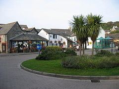
The town has a few hotels and guesthouses but numerous shops and pubs.
Surfing
Since the closing years of the 20th century, the village has become a hub for surfing as it is on the main road gateway to three of the South West's surf beaches of Saunton, Croyde and Putsborough, all with fine powdery sand, and to a lesser extent a road to Woolacombe). The Museum of British Surfing opened in 2012 in the old goods shed of the old Braunton Railway Station on the Ilfracombe Branch Line.
A number of major surf brands are associated with the village including Tiki and Salt Rock.