
Isolation 15.38 mi (24.75 km) Prominence 507 m | Elevation 4,115 m | |
 | ||
Listing North America highest peaks 94thUS highest major peaks 77thColorado highest major peaks 40th Topo map USGS 7.5' topographic mapMonarch Lake, Colorado Similar Parry Peak, Grizzly Peak, Rio Grande Pyramid, Bard Peak, Hagues Peak | ||
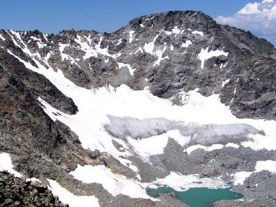
North Arapaho Peak is the highest summit of the Indian Peaks in the northern Front Range of the Rocky Mountains of North America. The 13,508-foot (4,117 m) thirteener is located in the Indian Peaks Wilderness, 7.8 miles (12.6 km) west-southwest (bearing 245°) of the Town of Ward, Colorado, United States, on the Continental Divide separating Roosevelt National Forest and Boulder County from Arapaho National Forest and Grand County.
Contents
Map of North Arapaho Peak, Colorado 80466, USA
Between North Arapaho Peak and neighboring South Arapaho Peak sits Arapaho Glacier, which is owned by the City of Boulder as part of its water supply. West of these peaks is Arapaho Pass.
Historical namesEdit
References
North Arapaho Peak Wikipedia(Text) CC BY-SA