
Length 48 km | ||
 | ||
River mouth McKellar Lake200 ft (61 m) Similar Mall of Memphis, Tom Lee Park, Lower Hatchie National, T O Fuller State Park, Mud Island | ||
Nonconnah Creek or the Nonconnah Creek Drainage Canal is a 29.7-mile-long (47.8 km) waterway in southwest Tennessee. It starts in extreme southeastern Shelby County, Tennessee, near the town of Collierville. From there, it flows westward, forming the southern border of Germantown. The creek continues to flow west through Memphis and through Whitehaven. Nonconnah Creek empties into McKellar Lake, an oxbow of the Mississippi River. There are three major expressways that follow most of its route. These are Interstate 55, Interstate 240, and Tennessee State Route 385, formerly named and still locally referred to as "Nonconnah Parkway".
Contents
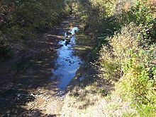
- Map of Nonconnah Creek Tennessee USA
- HistoryEdit
- Drainage basinEdit
- Streamflow USGSEdit
- Major floodingEdit
- Backwater floodingEdit
- GreenbeltEdit
- References
Map of Nonconnah Creek, Tennessee, USA
HistoryEdit
Nonconnah Creek was created from glacial runoff around 12,000 years ago. Prior to around year 400, the creek flowed from its headwaters west-northwesterly until the location of the present-day I-240/TN 385 interchange. From there it continued across what is now East Memphis and Midtown and connected with the Wolf River just before it empties into the Mississippi River. Around CE 400, a massive seismic event in the Ellendale Fault (part of the New Madrid Fault system) raised a low ridge across present-day east Memphis, diverting Nonconnah Creek away from the Wolf, causing it to flow directly into the Mississippi River several miles south of the Wolf's mouth. The lowermost section of the Nonconnah that continued to flow into the Wolf eventually became known as Cypress Creek.
Nonconnah Creek was widened and channelized in the 20th century (like many of the rivers in West Tennessee) from its mouth to near Houston Levee Road in Collierville.
Drainage basinEdit
The Nonconnah Creek watershed covers parts of two counties in Tennessee (Shelby and Fayette) and two counties in Mississippi (Marshall and Desoto). The creek drains approximately half of the city of Memphis, the rest being drained by the Wolf River.
Streamflow | USGSEdit
The NONCONNAH CREEK Streamflow data is posted on line by the USGS National Water Information System: Web Interface.
Major floodingEdit
Major floods occurred in the basin on 21 November 1934, when 10.48 inches of rain fell in 24 hours, and on 9 May 1958, when 4.76 inches of rain fell in approximately eight hours. The most recent significant flood occurred on 3 December 1978, when 4.9 inches were recorded at the Memphis International Airport. The 1978 storm appears to be between the 5-year and 10-year frequency events. Under present day conditions, the 1934 and 1958 flood levels would cause considerably higher damages due to increased urbanization.
Backwater floodingEdit
If the Mississippi River gets above 40 feet on the Memphis river gauge, the Nonconnah, along with other local streams and rivers connected to the Mississippi, will begin to experience backwater flooding, which is when these streams begin to flow backwards as the Mississippi river rises and fills them. Backwater flooding occurred in both the 1927 and 1937 floods along the Mississippi River. In the 1940s, the U.S. Army Corps of Engineers built an earthen levee system with pumping stations along the northern side of Nonconnah Creek from its mouth to Prospect Street in South Memphis. During the 2011 Mississippi River floods, these levees kept water off of the northern side. However, backwater flooding occurred on the south side causing damage to several subdivisions. The creek also flowed backwards within its channel to the Lamar Avenue (U.S. Route 78) overpass.
GreenbeltEdit
The Nonconnah Greenbelt, a proposed system of trails, is currently being planned and constructed. If completed, it would stretch from Collierville to the Mississippi River. Phase I was completed in late 2007. It is located near Collierville near the intersection of TN 385 and Forest Hill Irene Road.