
Elevation 1,514 m | Parent range Swiss Prealps Prominence 289 m | |
 | ||
Similar Teysachaux, Dent de Lys, Rotenfluh, La Berra, Moléson | ||
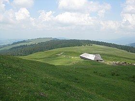
The Niremont (1,514 m) is a mountain of the Swiss Prealps, in the canton of Fribourg. Due to its rounded shape, it has 2 sub-summits : The Gros Niremont (1,481 m) and the Petit Niremont (1,493 m).
Contents
- Map of Niremont 1623 Semsales Switzerland
- ToponymyEdit
- SituationEdit
- HydrologyEdit
- Fauna and floraEdit
- ActivitiesEdit
- References
Map of Niremont, 1623 Semsales, Switzerland
ToponymyEdit
Its name means Noir Mont in French ("Black Mountain").
SituationEdit
The Noirmont stands between the Swiss plateau and the Swiss Alps. The city of Châtel-St-Denis and the A12 motorway are located on its western foot.
The panorama from its summit offers a nice view on the Moléson, the village of Les Paccots, the lake of Geneva and the Jura Mountains.
HydrologyEdit
Several small tributaries on the west slopes feed the Trême river. On its south side lies the Veveyse de Châtel river, feeding the lake of Geneva.
Fauna and floraEdit
The Niremont is covered with pine forests, wetlands and mires. A great proportion (402 hectares) is registered on the Inventory of Mire Landscapes of Particular Beauty and National Importance.
ActivitiesEdit
The small ski resort of Rathvel lies on its eastern slopes. The Niremont is a popular destination for hiking, mountain biking, snowshoeing and ski touring.