
Elevation 2,002 m | Parent range Vaud Alps Prominence 512 m Mountain range Alps, Bernese Alps | |
 | ||
Similar Rochers de Naye, La Berra, Teysachaux, Vanil Noir, Dent de Lys | ||
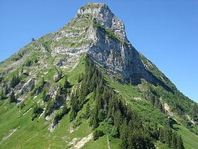
The Moléson (French: Le Moléson) (2,002 metres) is a mountain of the Swiss Prealps, overlooking the region of Gruyères in the canton of Fribourg. It lies at the northern end of the chain between Lake Geneva and the valley of the Sarine.
Map of Mol%C3%A9son, 1663 Gruy%C3%A8res, Switzerland
The summit of the mountain can be easily reached, a cable car station being located near the summit at 1,982 metres as well as a meteorological station. From the village of Moléson-sur-Gruyères a funicular leads to Plan Francey (1,517 m), from where the cable car starts.
References
Moléson Wikipedia(Text) CC BY-SA