
Length 187 km (116 mi) | Width 50 km (31 mi) Elevation 1,231 m | |
 | ||
Provinces | ||
Nipe-Sagua-Baracoa, also known as Macizo Nipe Sagua Baracoa ("Nipe Sagua Baracoa Massif"), is a mountain range of eastern Cuba.
Contents
Geography
The range is located in Holguín Province and Guantánamo Province, and slightly into Santiago de Cuba Province.
Extended for a length of 187 km and a width of 50, the Nipe-Sagua-Baracoa spans from the central-eastern part of the Province of Holguín (near Nipe Bay, Mayarí) to the eastern corner of the one of Guantánamo, up to Maisí. It borders with the mountain range of Sierra Maestra and counts the Pico Cristal that, with an elevation of 1,231 m, is the second Cuban peak after the Pico Turquino (1,974 m).
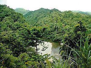
The range is crossed by the rivers Toa, Mayarí and Sagua de Tánamo.
Composition
The range is composed by several subgroups:
Environment
Nipe-Sagua-Baracoa is known for its biodiversity and counts the national parks of Sierra Cristal and Alejandro de Humboldt, and the biosphere reserve of Cuchillas del Toa.