
Area 6,164 km² | Time zone EST (UTC-5) Population 510,863 (31 Dec 2010) | |
 | ||
Points of interest Sierra Maestra, Guantánamo Bay, Concatedral de Nuestra Señora d, El Yunque, Museo Municipal | ||
Cuba tortugilla beautiful non touristy spot between baracoa guant namo
Guantánamo is the easternmost province of Cuba. Its capital is also called Guantánamo. Other towns include Baracoa. The province has the only land border of the important U.S. Navy base at Guantánamo Bay.
Contents
- Cuba tortugilla beautiful non touristy spot between baracoa guant namo
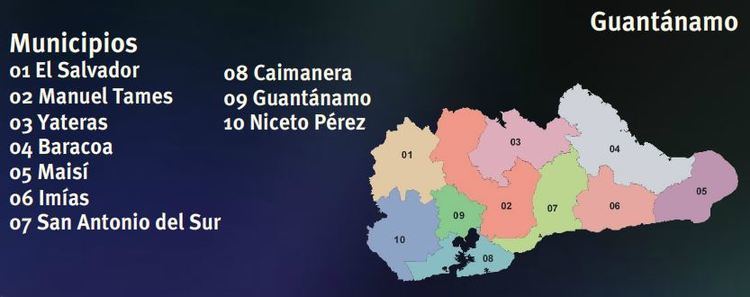
- Map of GuantC3A1namo Cuba
- Overview
- Municipalities
- References
Map of Guant%C3%A1namo, Cuba
Overview
Guantánamo's architecture and culture is unlike the rest of Cuba. The province is only 80 km away from Haiti its closest point, across the Windward Passage and close enough to see lights on Haiti on a clear night. Guantánamo also has a high number of immigrants from Jamaica, meaning that many buildings are comparable to those of the French Quarter of New Orleans in the U.S. state of Louisiana.
The Nipe-Sagua-Baracoa mountains dominate the province, dividing both climate and landscape. The northern coast, battered by prevailing winds, is the wettest part of the country, while the south, sheltered and dry, is the hottest. The north is characterized by rainforests, while the south is arid and has many cacti.
Municipalities
- Baracoa
- Caimanera
- El Salvador
- Guantánamo
- Imías
- Maisí (La Máquina)
- Manuel Tames
- Niceto Pérez
- San Antonio del Sur
- Yateras (Palenque)