
 | ||
The Nikkō Kaidō (日光街道) was one of the five routes of the Edo period and it was built to connect Edo (modern-day Tokyo) with the Nikkō Tōshō-gū, which is located in the present-day city of Nikkō, Tochigi Prefecture, Japan. It was established in 1617 by Tokugawa Ieyasu, in order for him to have a smoother route to the shrine. With only twenty-one stations, the Nikkō Kaidō was the shortest of the five routes, but it shares seventeen stations with the Ōshū Kaidō. Part of its route can be traced with Japan's Route 4.
Contents
- Map of Nikko Highway Japan
- Stations of the Nikk Kaid
- Tokyo
- Saitama Prefecture
- Ibaraki Prefecture
- Tochigi Prefecture
- References
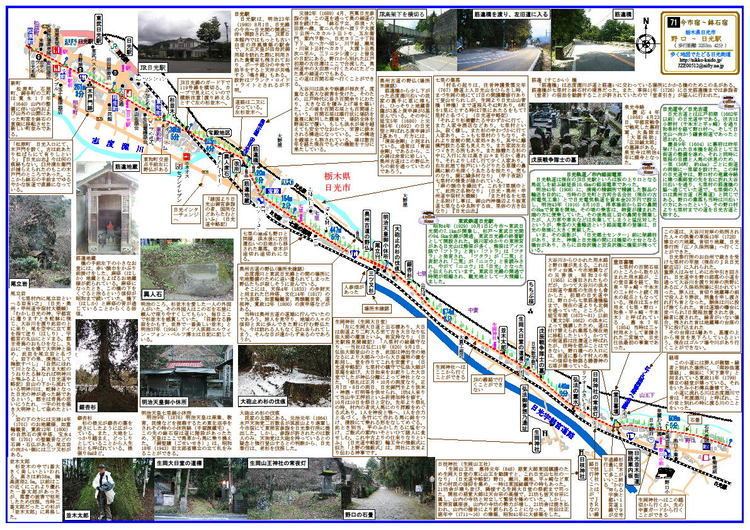
Map of Nikko Highway, Japan
Stations of the Nikkō Kaidō
The 21 stations of the Nikkō Kaidō are listed below in order and are divided by their modern-day prefecture. The present day municipality is listed afterwards in parentheses.
Tokyo
Starting Location: Nihonbashi (日本橋) (Chūō-ku)1. Senju-shuku (千住宿) (Adachi-ku) (also part of the Mito Kaidō)Saitama Prefecture
2. Sōka-shuku (草加宿) (Sōka)3. Koshigaya-shuku (越ヶ谷宿) (Koshigaya)4. Kasukabe-shuku (粕壁宿) (Kasukabe)5. Sugito-shuku (杉戸宿) (Sugito, Kitakatsushika District)6. Satte-shuku (幸手宿) (Satte)7. Kurihashi-shuku (栗橋宿) (Kuki)Ibaraki Prefecture
8. Nakada-shuku (中田宿) (Koga)9. Koga-shuku (古河宿) (Koga)Tochigi Prefecture
10. Nogi-shuku (野木宿) (Nogi, Shimotsuga District)11. Mamada-shuku (間々田宿) (Oyama)12. Oyama-shuku (小山宿) (Oyama)13. Shinden-shuku (新田宿) (Oyama)14. Koganei-shuku (小金井宿) (Shimotsuke)15. Ishibashi-shuku (石橋宿) (Shimotsuke)16. Suzumenomiya-shuku (雀宮宿) (Utsunomiya)17. Utsunomiya-shuku (宇都宮宿) (Utsunomiya)18. Tokujirō-shuku (徳次郎宿) (Utsunomiya)19. Ōzawa-shuku (大沢宿) (Nikkō)20. Imaichi-shuku (今市宿) (Nikkō) (also part of the Nikkō Reiheishi Kaidō)21. Hatsuishi-shuku (鉢石宿) (Nikkō)Ending Location: Nikkō Tōshō-gū (日光東照宮) (Nikkō)References
Nikkō Kaidō Wikipedia(Text) CC BY-SA