
Elevation 80-618 m (−1,948 ft) Area 7.38 km² Population 754 (31 Dec 2008) Dialling code 06743 | Municipal assoc. Rhein-Nahe Time zone CET/CEST (UTC+1/+2) Local time Monday 9:32 AM Postal code 55413 | |
 | ||
Weather 9°C, Wind E at 10 km/h, 56% Humidity | ||
Niederheimbach is an Ortsgemeinde – a municipality belonging to a Verbandsgemeinde, a kind of collective municipality – in the Mainz-Bingen district in Rhineland-Palatinate, Germany.
Contents
- Map of 55413 Niederheimbach Germany
- Location
- Municipal council
- Town partnerships
- Coat of arms
- Buildings
- Regular events
- Transport
- Documents
- References
Map of 55413 Niederheimbach, Germany
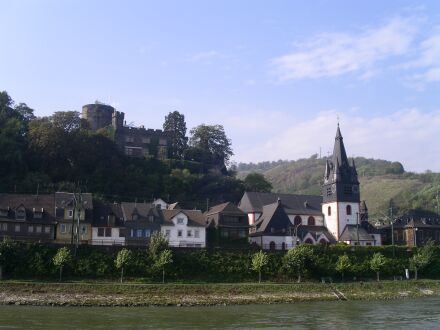
The winegrowing centre belongs to the Verbandsgemeinde of Rhein-Nahe, whose seat is in Bingen am Rhein, although that town is not within its bounds. Since 2003, Niederheimbach has been part of the Rhine Gorge UNESCO World Heritage Site.
Location
Niederheimbach lies between Koblenz and Bingen, right on the Rhine Gorge, only a short way northwest of the Rhine Knee. The place, which is found beneath or east of Bingen Forest (Binger Wald), has a built-up area stretching from 80 to 140 m above sea level. The highest mountain in the municipal area, at 618 m above sea level, is the heavily wooded Franzosenkopf (“Frenchman’s Head”), found south of the built-up area in Bingen Forest.
Municipal council
The council is made up of 13 council members, counting the part-time mayor, with seats apportioned thus:
(as at municipal election held on 13 June 2004)
Town partnerships
Coat of arms
The municipality’s arms might be described thus: Per bend sinister wavy, a bendlet sinister wavy argent surmounting the partition, gules in dexter an abbot’s staff per bend surmounted by a bishop’s mitre, in chief a wheel spoked of six of the first, sable in sinister a bunch of grapes per bend slipped and a grapeleaf in bend sinister Or and issuant from base a lion rampant of the fourth armed, langued and crowned of the second.
Buildings
Regular events
Until its closure in the 1990s, the Märchenhain (“Fairytale Grove”) was a tourist attraction. A great number of the fairytale figures were nonetheless restored and have found a new place along an idyllic pathway near the community. There one can see many fairytales, such as Little Red Riding Hood, Hansel and Gretel and others along the Kuhweg (“Cow Way”).