
Highest point Malakatyn Tas Elevation 374 m | Highest elevation 374 m (1,227 ft) Area 29,900 km² | |
 | ||
Federal subject Sakha Republic (Yakutia) Islands New Siberia, Kotelny Island, Bolshoy Lyakhovsky Island, Yaya Island | ||
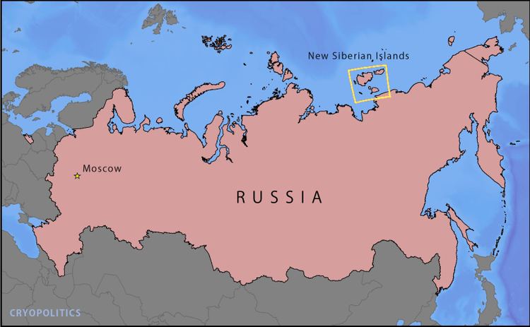
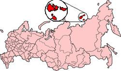
The New Siberian Islands (Russian: Новосиби́рские острова, Novosibirskiye Ostrova) are an archipelago in the Extreme North of Russia, to the North of the East Siberian coast between the Laptev Sea and the East Siberian Sea north of the Sakha (Yakutia) Republic.
Contents
New siberian islands
History
The first news about the existence of the New Siberian Islands was brought by a Cossack, Yakov Permyakov, in the beginning of the 18th century. In 1712, a Cossack unit led by M. Vagin reached the Great Lyakhovsky Island. At the beginning of the 19th century, the islands were further explored by Yakov Sannikov, Matvei Gedenschtrom and others.
In 1809–10 Yakov Sannikov and Matvei Gedenschtrom went to the New Siberian Islands on a cartographic expedition. Yakov Sannikov reported the sighting of a "new land" north of Kotelny in 1811. This became the myth of Zemlya Sannikova or Sannikov Land.
In 1886 Eduard von Toll, during his first visit to the New Siberian Islands, thought that he had seen an unknown land north of Kotelny Island. He guessed that this was the so-called Zemlya Sannikova.
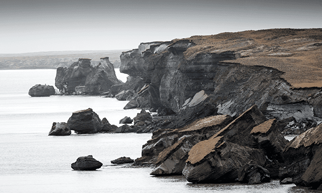
Polar explorer and scientist Eduard Toll paid a further visit to this island group in the spring of 1892, accompanied only by one Cossack and three natives. He traveled over the ice in sleds drawn by dogs and reached the south coast of Great Lyakhovsky Island. Along the southern coast of this island he found well-preserved bones, ivory, peat, wood, and even a tree within 40-meter (130-foot) high sea cliffs that expose Late Pleistocene sediments. These sediments are cemented by permafrost and have accumulated periodically over the last 200,000 years.
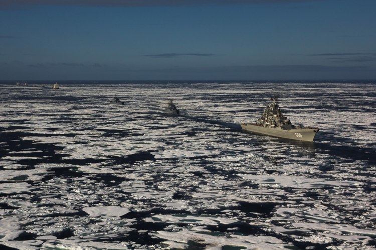
In September 2014, the Russian Navy re-established a Soviet era naval base which had laid abandoned since 1993.
Geography
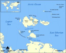
The New Siberian Islands proper, or Anzhu Islands (острова Анжу, Sakha: Анжу арыылара), covering a land area of about 29,000 km², consist of:
To the south and nearer to the Siberian mainland lie the Lyakhovskiye Islands (6,095 km²):
The small De Long Islands (228 km²) lie to the north-east of Novaya Sibir.
The New Siberian Islands are low-lying. Their highest point is Mt. Malakatyn-Tas on Kotelny island, with an elevation of 374 m.
The New Siberian Islands once formed major hills within the Great Arctic Plain that covered the northern part of Late Pleistocene "Beringia" between Siberia and Alaska during the Last Glacial Maximum (Late Weichselian Epoch). These islands represent the remains of about 1.6 million square kilometers of the formerly subaerial Great Arctic Plain that now lies submerged below parts of the Arctic Ocean, East Siberian Sea, and Laptev Sea. At this plain's greatest extent, sea level was 100–120 m below modern sea-level and the coastline lay 700 to 1000 kilometers north of its current position. This plain did not undergo extensive glaciation during the Late Pleistocene or the Last Glacial Maximum because it lay in the rain shadow of the Northern European ice sheet. During the frigid polar climate of the Last Glacial Maximum, 17,000 to 24,000 BC, small passive ice caps formed on the adjacent De Long Islands. Fragments of these ice caps remain on Jeannette, Henrietta, and Bennett Islands. Traces of former small slope and cirque glaciers in the form of buried ground ice deposits are preserved on Zhokhov Island. The sea submerged the Great Arctic Plain (except for the New Siberian and other isolated islands) within a relatively short time span of 7,000 years during the Early–Middle Holocene.
Geology
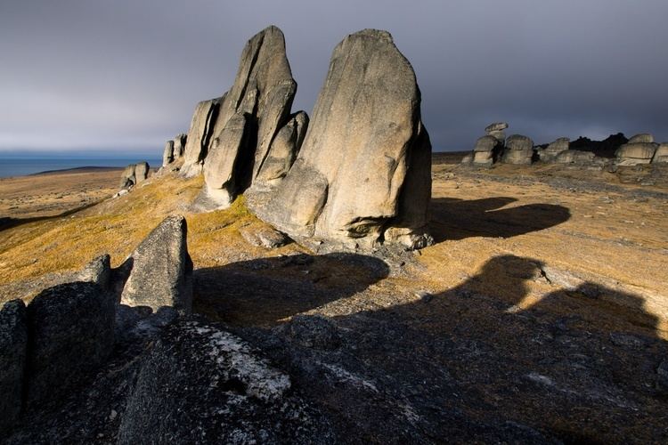
As noted by Digby and numerous later publications, this archipelago consists of a mixture of folded and faulted sedimentary and igneous rocks ranging in age from Precambrian to Pliocene. The Lyakhovsky Islands consist of a folded and faulted assemblage of Precambrian metamorphic rocks; upper Paleozoic to Triassic sandstones and shales; Jurassic to lower Cretaceous turbidites; Cretaceous granites; and ophiolites. The Anzhu Islands consist of a highly faulted and folded assemblage of Ordovician to Devonian limestones, dolomites, sandstones, shales, volcanoclastic strata, and igneous rocks; upper Paleozoic to Triassic sandstones and shales; Jurassic to lower Cretaceous turbidites; and upper Cretaceous to Pliocene sandstones and shales. The De Long Islands consist of early Paleozoic, middle Paleozoic, Cretaceous, and Neogene sedimentary and igneous (mostly basalt) rocks. These sedimentary, metamorphic, and igneous rocks are mantled by loose Pleistocene and Holocene sediments that range in thickness from a fraction of a meter to about 35 meters (115 feet).
Digby also noted that some early papers published about the New Siberian Islands incorrectly describe them, often along with other Arctic islands (e.g. Wrangel Island), as being made either up almost entirely of mammoth bones and tusks or of ice, sand, and the bones of mammoths and other extinct megafauna. Some of these papers were written by persons (e.g. D. G. Whitney), who had never visited the New Siberian Islands and relied upon anecdotes of traders and travelers and local folklore for their descriptions of them, and other articles were written by explorers and ivory hunters untrained in either geology or other sciences. Such statements have been shown to be fictional in nature by detailed studies of the geology of the New Siberian Islands by professional geologists, paleontologists, and other scientists.
Ivory deposits
As noted by Baron Eduard V. Toll in his account of the New Siberian Islands, sizable and economically significant accumulations of fossil ivory occur within them. The ivory, along with mammoth and other bones, are found in recent beaches, drainage areas, river terraces and river beds. The New Siberian Islands are unique in the burial and preservation of fossil ivory "...in such a wonderful state of preservation that the tusks so found cannot be distinguished from the very best and purest ivory." The abundant bones, even skeletons, of mammoth, rhinoceros, musk-ox, and other megafauna along with the mammoth ivory found in these islands are preserved by permafrost, in which they are encased. The permafrost periodically developed in Late Pleistocene loess, solifluction, pond, and stream sediments as they accumulated. The radiocarbon dating of bones, ivory, and plants; optically stimulated luminescence dating of enclosing sediments; and uranium-thorium dating of associated peats demonstrate that the bones and ivory, which are found within some of the New Siberian Islands, accumulated over a period of some 200,000 years. Radiocarbon dates obtained from the collagen of 87 mammoth tusks and bones collected from Faddeevsky, Kotelniy, and New Siberia islands ranged from 9470±40 BP to greater than 50,000 BP (14C). Their "wonderful state of preservation" is the result of them having been frozen in permafrost since their burial.
Climate
The climate is arctic and severe. Snow cover is present for 9 months of the year.
Permafrost and underground ice are very common. The surface of the islands is covered with Arctic tundra vegetation and numerous lakes.
The ocean surrounding the islands is covered with ice most of the year. During warm years, the ocean briefly opens for navigation July through October. During cold years, islands may remain ice-locked through the summer.
Polar night conditions are present November through February, and, conversely, the Sun remains above the horizon continuously during summer months.