
Existed: 1953 – present Constructed 1953 | Length 240 m | |
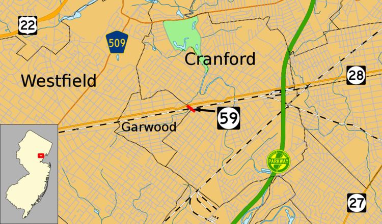 | ||
Route 59, at 0.15-mile (0.24 km) long, is the shortest state highway in New Jersey, United States. The route consists entirely of a short block of Lincoln Avenue from Union County Route 610 (known locally as South Avenue) in Cranford to New Jersey Route 28 (known locally as North Avenue) along the Cranford–Garwood border. The route functions as an underpass under the Raritan Valley Line of New Jersey Transit, under which it crosses about halfway down the block, along the municipal border. Route 59 was originally a proposed alignment of Route 22, which was supposed to head from an intersection with current day New Jersey Route 159 in Morris County at the Pine Brook Bridge before heading through several counties, terminating at an intersection with New Jersey Route 27 in Rahway. Most of the route was not constructed, and a portion in Garwood and Cranford was re-designated Route 59 in the 1953 New Jersey state highway renumbering on January 1, 1953.
Contents
Map of NJ-59, New Jersey, USA
Route description
Route 59 begins at a four-way intersection with Union County Route 610 (CR 610; South Avenue) in the community of Cranford. Route 59 heads northwestward, passing a couple of businesses in both directions. The route crosses under the New Jersey Transit-owned Raritan Valley Line at which point the border of Cranford and Garwood runs along the center of the road. The route continues to the northwest, passing businesses before ending at a signalized T-intersection with Route 28 (North Avenue). The pavement ends at the intersection though a state-constructed bridge carrying the intersection over a small creek is angled such that a road could continue northwest. Throughout the entire length of the route, it is four lanes wide (two in each direction). There is no signed speed limit on any portion of the route.
History
The alignment of Route 59 was designated as part of the proposed State Highway Route 22 in the 1927 renumbering, which was proposed to run from the Pine Brook Bridge over the Passaic River at State Highway Route 6 in Fairfield Township. (This intersection is currently where New Jersey Route 159 currently crosses the bridge.) The route was to continue through parts of Morris, Essex and Union counties, including intersections with State Highway Route 10 at Livingston, U.S. Route 22 (also State Highway Route 29) at Mountainside, State Highway Route 28 at Garwood (where Routes 28 and 59 currently meet), and terminate in the community of Rahway at State Highway Route 27. Most of this route was not constructed, except a portion from State Highway Route 28 (North Avenue) in Cranford to South Avenue in Garwood. This portion was renumbered as Route 59 in the 1953 New Jersey state highway renumbering on January 1, 1953 so as not to duplicate U.S. Route 22.
Major intersections
The entire route is in Union County.