
Existed: 1963 – present Length 5 km | Constructed 1963 | |
 | ||
County | ||
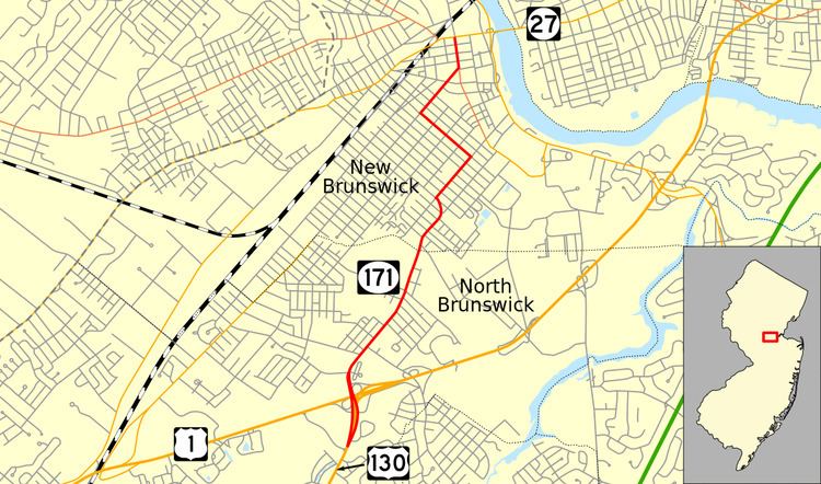
Route 171 is a state highway in New Jersey, United States. It runs 3.10 miles (4.99 km) as an extension of U.S. Route 130 past its northern terminus at U.S. Route 1 in North Brunswick Township, New Jersey. Although its northern terminus is at an intersection with Route 27 in New Brunswick, the route is unsigned inside New Brunswick. The route is a major thoroughfare in North Brunswick and in New Brunswick, running on major city streets. The route originated as an alignment of pre-1927 Route 1 and later of U.S. Route 130. After Route 130 was truncated, the alignment, which had also been designated Route 25M was later re-designated as Route 171.
Contents
Map of NJ-171, New Jersey, USA
Route description
Route 171 begins at an intersection with U.S. Route 130 and U.S. Route 1 in the town of North Brunswick. The route, which continues as a right-of-way for U.S. Route 130, heads northward along Georges Road. At an intersection with Cranbury Cross Road, Route 171 turns to the northeast. The route heads northward, passing the Brunswick Shopping Center and intersects with County Route 606 (Milltown Road). The route continues to the northwest through North Brunswick, passing Van Liew Cemetery. After an intersection with County Route 620 (Nassau Street) and crossing into New Brunswick at Elmwood Cemetery. The route passes Baker Park and enters the residential districts of New Brunswick. At an intersection with Jones Avenue, Route 171 makes a curve to the northwest, intersecting with Commercial Avenue.
At that intersection, Route 171 turns to the northeast and follows Commercial Avenue northbound. The route intersects with several local roads, paralleling County Route 691 (Livingston Avenue) to the west. Route 171 continues through New Brunswick, passing Feaster Park. The route intersects with Suydam Street, where it turns westward until the intersection with Livingston Avenue, the southern terminus of County Route 691. The route turns northward again along Livingston Avenue. The route continues northward into the Theatre District of New Brunswick. At an intersection with George Street (County Route 672), Route 171 and Route 672 head westward on a concurrency through downtown New Brunswick. Route 171 terminates at an intersection with New Jersey Route 27 and County Route 514 in New Brunswick. County Route 672 continues further in New Brunswick after Route 171 ends.
History
The highway dates back to the alignment of Route 1, assigned in the early 1920s. The designation remained in place until the 1927 New Jersey State highway renumbering, when New Jersey Route 25 was designated onto the alignment of U.S. Route 130, which was also designated in 1927. Route 25 was aligned on the entire alignment of Route 171, but by 1930, the route was realigned onto U.S. Route 1. The alignment of U.S. Route 130 remained along the alignment of Route 171 for several years, and by 1940, the northern alignment of Route 171 was designated as Route 25M. In the 1953 renumbering, Route 25M was redesignated Route 171, when Route 25 was decommissioned.
Major intersections
The entire route is in Middlesex County.