
Existed: 1953 – present Counties: Ocean Constructed 1953 | Length 900 m | |
 | ||
West end: CR 632 in Point Pleasant | ||
Route 13 is a short state highway in the communities of Point Pleasant and Bay Head, New Jersey, both of which are in Ocean County. The route consists of the Lovelandtown Bridge, and a distinct part of Bridge Avenue, which is mostly maintained by the county as County Route 632. The route is unsigned, designated in the 1953 New Jersey state highway renumbering as a re-designation of Route 13E from Hollywood Boulevard to Bay Avenue.
Contents
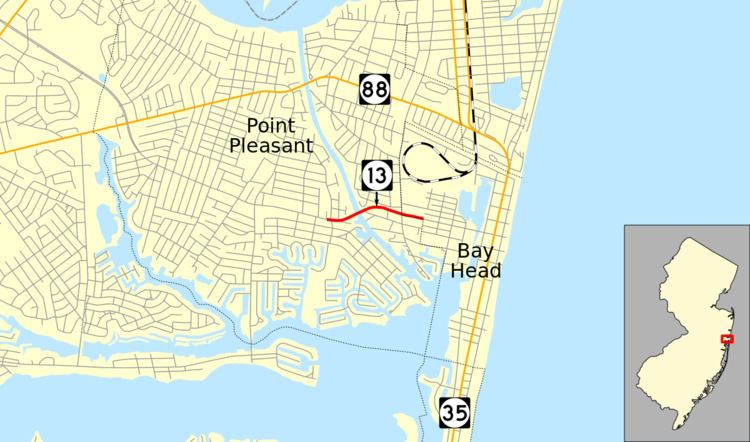
Map of NJ-13, Point Pleasant, NJ 08742, USA
The route was first assigned in 1938, when the state took over maintenance of the fifth segment of Ocean County Route 13 built in 1929, intending it for reaching New Jersey Route 37 in Bay Head from Beaver Dam Road, a distance of 1.76 miles (2.83 km). The takeover did not reach that point, and the bridge and its approaches count for 0.56 miles (0.90 km) of the intended length. Route 13 received several reconstructions since 1929, including a replacement in 1971 and rehabilitation in 2005.
Route description
Route 13 begins at an intersection where Ocean County Route 632 meets Hollywood Place in Point Pleasant. There, the state-maintenance begins. The route heads eastward along Bridge Avenue, passing to the south of local businesses and to the north of local residences. There, Route 13 begins a curve to the northeast onto the Lovelandtown Bridge approach, crossing some dead-end local roads and a marina before reaching the Point Pleasant Canal and onto the lift bridge. The bridge soon re-enters land, where it parallels Elm Avenue for a short distance before turning away to the southeast. The route heads into downtown Bay Head, where it reaches an intersection with Bay Avenue, which denonates its eastern terminus. County Route 632 continues eastward to New Jersey Route 35.
History
Originally, the bridge over the Point Pleasant Canal, the Lovelandtown Bridge, was constructed in 1929 for a continuous route above Bridge Avenue. The designation of Route 13 originated as an alignment of Ocean County Route 13-E, a highway maintained by the county. In 1938, the state legislated a takeover of the fifth segment of the county route, a portion of highway from New Jersey Route 37 at Bay Head to an intersection with Beaver Dam Road, including the Lovelandtown Bridge. The route was to be 1.76 miles (2.83 km) long, but the extension was never produced. In the 1953 renumbering, the state dropped the suffix and renumbered the bridge and its approaches to Route 13.
During a storm in 1962, the bridge built in 1929 was swept away in a storm and rebuilt. The bridge was then replaced in 1971 with a 291.01 feet (88.70 m) long steel lift bridge. The bridge has remained virtually intact since. Structurally, Route 13 was a rehabilitation on the bridge and its approaches in October 2004. The bridge construction was completed by Carr & Duff Inc., which had received the project in June of that year. The Department of Transportation and Governor James E. McGreevey forwarded $2.4 million (2005 USD) to the company for construction.
Major intersections
The entire route is in Ocean County.