
 | ||
Similar Barnegat Inlet, Cape May Canal, Shark River, Big Flat Brook, Island Beach State Park | ||
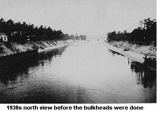
The Point Pleasant Canal is a canal in Point Pleasant, New Jersey. It was completed in late 1925 to connect the Manasquan Inlet and Manasquan River with Bay Head Harbor on the northern end of the Barnegat Bay. It is also a section of the Intracoastal Waterway.
Map of Point Pleasant Canal, Point Pleasant, NJ 08742, USA
With the completion of the canal, the Barnegat Peninsula has effectively become an island. The Island is now connected to the main-land by two lift bridges that span the canal.
Two lift bridges over the canal, at Route 88 and Bridge Avenue (the Lovelandtown Bridge), are opened as often as 300 times per day during the summer to allow boats to pass underneath as marine traffic has the right of way.
References
Point Pleasant Canal Wikipedia(Text) CC BY-SA