
Counties: Coos | Length 40 km | |
 | ||
County Coös County, New Hampshire | ||
New hampshire route 110 stark nh white mountains w yuneec q500 typhoon drone
New Hampshire Route 110 (abbreviated NH 110) is a 24.856-mile-long (40.002 km) east–west state highway in Coos County, northern New Hampshire, United States. The road winds through the scenic, mountainous country of New Hampshire north of the White Mountain National Forest. NH 110 is locally named the Berlin-Groveton Highway.
Contents
- New hampshire route 110 stark nh white mountains w yuneec q500 typhoon drone
- Map of NH 110 New Hampshire USA
- Major intersections
- New Hampshire Route 110A
- New Hampshire Route 110B
- References
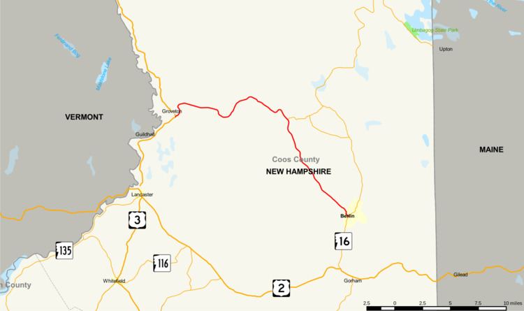
Map of NH-110, New Hampshire, USA
The eastern terminus of NH 110 is in Berlin at New Hampshire Route 16 (White Mountain Road). The western terminus of NH 110 is at U.S. Route 3 in the village of Groveton, town of Northumberland, on the Connecticut River.
Major intersections
The entire route is in Coos County.
New Hampshire Route 110A
New Hampshire Route 110A (abbreviated NH 110A) is a 3.897-mile-long (6.272 km) connector road in the town of Milan, north of Berlin, United States. NH 110A is locally named Cedar Pond Road.
The eastern terminus of NH 110A is at New Hampshire Route 16 (White Mountain Road) 12 miles (19.3 km) north of Berlin. The western terminus is at New Hampshire Route 110 11.2 miles (18 km) northwest of Berlin.
New Hampshire Route 110B
New Hampshire Route 110B (abbreviated NH 110B) is a 4.626-mile-long (7.445 km) connector road in the town of Milan, New Hampshire, north of Berlin. NH 110B is locally named Milan Hill Road.
The eastern terminus of NH 110B is at New Hampshire Route 16 near the Berlin Regional Airport. The western terminus is at New Hampshire Route 110A near Cedar Pond.