
 | ||
What s left of new amsterdam in lower manhattan 2 4
New Amsterdam (Dutch: Nieuw Amsterdam) was a 17th-century Dutch settlement established at the southern tip of Manhattan Island, which served as the seat of the colonial government in New Netherland. The factorij became a settlement outside of Fort Amsterdam. Situated on the strategic, fortifiable southern tip of the island of Manhattan, the fort was meant to defend the Dutch West India Company's fur trade operations in the North River (Hudson River). In 1624 it became a provincial extension of the Dutch Republic and was designated as the capital of the province in 1625.
Contents
- What s left of new amsterdam in lower manhattan 2 4
- Early settlement 16091625
- Pilgrims attempt to settle in the Hudson River area
- The Dutch return
- Fort Amsterdam 1625
- 16251664
- English capture
- Maps of New Amsterdam
- Layout
- Legacy
- References
New Amsterdam was renamed New York on September 8, 1664, in honor of the then Duke of York (later James II of England), in whose name the English had captured it. After the Second Anglo-Dutch War of 1665–1667, England and the United Provinces of the Netherlands agreed in the Treaty of Breda (1667) to the status quo: the English kept the island of Manhattan, the Dutch giving up their claim to the town and the rest of the colony, while in return the English formally abandoned the island of Run in the East Indies to the Dutch, confirming their control of the valuable Spice Islands.
Early settlement (1609–1625)

In 1524, nearly a century before the arrival of the Dutch, the site that later became New Amsterdam was named New Angoulême by the Italian explorer Giovanni da Verrazzano, to commemorate his patron King Francis I of France, former Count of Angoulême. The first recorded exploration by the Dutch of the area around what is now called New York Bay was in 1609 with the voyage of the ship Halve Maen (English: "Half Moon"), captained by Henry Hudson in the service of the Dutch Republic, as the emissary of Maurice of Nassau, Prince of Orange, Holland's stadholder. Hudson named the river the Mauritius River. He was covertly attempting to find the Northwest Passage for the Dutch East India Company. Instead, he brought back news about the possibility of exploitation of beaver by the Dutch who sent commercial, private missions to the area the following years.
At the time, beaver pelts were highly prized in Europe, because the fur could be felted to make waterproof hats. A by-product of the trade in beaver pelts was castoreum—the secretion of the animals' anal glands—which was used for its medicinal properties and for perfumes. The expeditions by Adriaen Block and Hendrick Christiaensen in 1611, 1612, 1613 and 1614 resulted in the surveying and charting of the region from the 38th parallel to the 45th parallel. On their 1614 map, which gave them a four-year trade monopoly under a patent of the States General, they named the newly discovered and mapped territory New Netherland for the first time. It also showed the first year-round trading presence in New Netherland, Fort Nassau, which would be replaced in 1624 by Fort Orange, which eventually grew into the town of Beverwyck, now Albany.
Dominican trader Juan Rodriguez (rendered in Dutch as Jan Rodrigues), born in Santo Domingo of Portuguese and African descent, arrived in Manhattan during the winter of 1613–1614, trapping for pelts and trading with the local population as a representative of the Dutch. He was the first recorded non-Native American inhabitant of what would eventually become New York City.
The territory of New Netherland was originally a private, profit-making commercial enterprise focusing on cementing alliances and conducting trade with the diverse Indian tribes. Surveying and exploration of the region was conducted as a prelude to an anticipated official settlement by the Dutch Republic, which occurred in 1624.
Pilgrims' attempt to settle in the Hudson River area
In 1620 the Pilgrims attempted to sail to the Hudson River from England. However, the Mayflower reached Cape Cod (now part of Massachusetts) on November 9, 1620, after a voyage of 64 days. For a variety of reasons, primarily a shortage of supplies, the Mayflower could not proceed to the Hudson River and the colonists decided to settle somewhere on or near Cape Cod.
The Dutch return
The mouth of the Hudson River was selected as the ideal place for initial settlement as it had easy access to the ocean while also securing an ice-free lifeline to the beaver trading post near present-day Albany, settled in 1614. Here American Indian hunters supplied them with pelts in exchange for European-made trade goods and wampum, which was soon being made by the Dutch on Long Island. In 1621 the Dutch West India Company was founded. Between 1621 and 1623, orders were given to the private, commercial traders to vacate the territory, thus opening up the territory to Dutch settlers and company traders. It also allowed the laws and ordinances of the states of Holland to apply. Previously, during the private, commercial period, only the law of the ship had applied.
In May 1624, the first settlers in New Netherland arrived on Noten Eylandt aboard the ship New Netherland under the command of Cornelius Jacobsen May, who disembarked on the island with thirty families in order to take legal possession of the New Netherland territory. The families were then dispersed to Fort Wilhelmus on Verhulsten Island (Burlington Island) in the South River (now the Delaware River), to Kievitshoek (now Old Saybrook, Connecticut) at the mouth of the Verse River (now the Connecticut River) and further north at Fort Nassau on the Mauritius or North River (now the Hudson River), near what is now Albany.
A fort and sawmill were soon erected at Nut Island. The latter was constructed by Franchoys Fezard, and was taken apart for iron in 1648.
Fort Amsterdam (1625)
The threat of attack from other European colonial powers prompted the directors of the Dutch West India Company to formulate a plan to protect the entrance to the Hudson River. In 1625 many settlers were moved from Noten Eylant to Manhattan Island, where a citadel to contain Fort Amsterdam was being laid out by Cryn Frederickz van Lobbrecht at the direction of Willem Verhulst. By the end of 1625, the site had been staked out directly south of Bowling Green on the site of the present U.S. Custom House. The Mohawk-Mahican War in the Hudson Valley led the company to relocate even more settlers to the vicinity of the new Fort Amsterdam. In the end, colonizing was a prohibitively expensive undertaking, only partly subsidized by the fur trade. This led to a scaling back of the original plans. By 1628, a smaller fort was constructed with walls containing a mixture of clay and sand.
The fort also served as the center of trading activity. It contained a barracks, the church, a house for the West India Company director and a warehouse for the storage of company goods. Troops from the fort used the triangle between the Heerestraat and what came to be known as Whitehall Street for marching drills.
1625–1664
Willem Verhulst, who, with his council, was responsible for the selection of Manhattan as a permanent place of settlement and for situating Fort Amsterdam, was replaced as the company director-general of New Amsterdam by Peter Minuit in 1626.
To legally safeguard the settlers' investments, possessions and farms on Manhattan island, Minuit negotiated the "purchase" of Manhattan from a Manahatta band of Lenape for 60 guilders worth of trade goods. According to the writer Nathaniel Benchley, Minuit conducted the transaction with the Lenape chief Seyseys, who was only too happy to accept valuable merchandise in exchange for an island that was actually mostly controlled by the Weckquaesgeeks. The deed itself has not survived, so the specific details are unknown. A textual reference to the deed became the foundation for the legend that Minuit had purchased Manhattan from the Native Americans for 24 dollars' worth of trinkets and beads, the guilder rate at the time being about two and a half to a Spanish dollar. In modern money, the price of 60 Dutch guilders in 1626 amounts to around $1,100 in 2012 dollars. Further complicating the calculation is that the value of goods in the area would have been different than the value of those same goods in the developed market of the Netherlands.
The Dutch exploited the hydropower of existing creeks by constructing mills at Turtle Bay (between present day East 45th- 48th Streets) and Montagne's Kill, later called Harlem Mill Creek (East 108th Street). In 1639 a sawmill was located in the northern forest at what was later the corner of East 74th Street and Second Avenue, at which African laborers cut lumber.
The New Amsterdam settlement had a population of approximately 270 people, including infants. In 1642 the new director-general Willem Kieft decided to build a stone church within the fort. The work was carried out by recent English immigrants, the brothers John and Richard Ogden. The church was finished in 1645 and stood until destroyed in the Slave Insurrection of 1741.
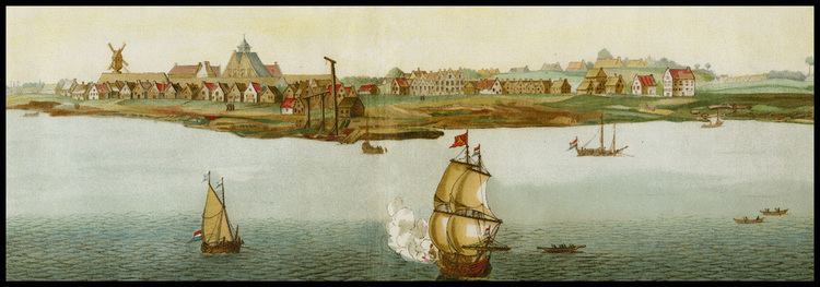
A pen-and-ink view of New Amsterdam, drawn on-the-spot and discovered in the map collection of the Austrian National Library in Vienna in 1991, provides a unique view of New Amsterdam as it appeared from Capske (small Cape) Rock in 1648. Capske Rock was situated in the water close to Manhattan between Manhattan and Noten Eylant, and signified the start of the East River roadstead.
New Amsterdam received municipal rights on February 2, 1653, thus becoming a city (Albany, then named Beverwyck, received its city rights in 1652.) Nieuw Haarlem (now known as Harlem) was formally recognized in 1658.
The first Jews known to have lived in New Amsterdam arrived in 1654. First to arrive were Solomon Pietersen and Jacob Barsimson, who sailed in the summer of 1654 directly from Holland, with passports that gave them permission to trade in the colony. Then in early September, 23 Jewish refugees arrived from the formerly Dutch city of Recife, which had been conquered by the Portuguese in January of that year. The director of New Amsterdam, Peter Stuyvesant, sought to turn them away but was ultimately overruled by the directors of the Dutch West India Company in Amsterdam. Asser Levy, an Ashkenazi Jew who was one of the 23 refugees, eventually prospered and in 1661 became the first Jew to own a house in New Amsterdam, which also made him the first Jew known to have owned a house anywhere in North America.
On September 15, 1655, New Amsterdam was attacked by 2,000 Indians, who destroyed 28 farms, killed 100 settlers, and took 150 prisoners.
English capture
On August 27, 1664, while England and the Dutch Republic were at peace, four English frigates sailed into New Amsterdam's harbor and demanded New Netherland's surrender, whereupon New Netherland was provisionally ceded by director-general Peter Stuyvesant. On September 6 Stuyvesant sent lawyer Johannes De Decker and five other delegates to sign the official Articles of Capitulation. This was swiftly followed by the Second Anglo-Dutch War, between England and the Dutch Republic. In June 1665, New Amsterdam was reincorporated under English law as New York City, named after the Duke of York (later King James II). He was the brother of the English King Charles II, who had been granted the lands.
That same year Jan van Bonnel built a saw mill on East 74th Street and the East River, where a 13,710-meter long creek or stream that began in the north of today's Central Park, which became known as the Saw Kill or Saw Kill Creek, emptied into the river. Later owners of the property George Elphinstone and Abraham Shotwell replaced the saw mill with a leather mill in 1677. The Saw-kill was later redirected into a culvert, arched over, and its trickling little stream called Arch Brook.
In 1667 the Treaty of Breda ended the conflict. The Dutch did not press their claims on New Netherland. In return, they were granted the tiny Island of Run in North Maluku, rich in nutmegs, and a guarantee for their de facto possession of Suriname, captured by them that year.
In July 1673, during the Third Anglo-Dutch War, the Dutch briefly occupied New York City and renamed it New Orange. Anthony Colve was installed as the first governor. Previously there had only been West India Company Directors. After the signing of the Treaty of Westminster in November 1674, the city was relinquished to the English and the name reverted to "New York". Suriname became an official Dutch possession in return.
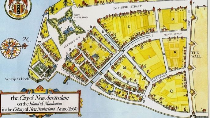
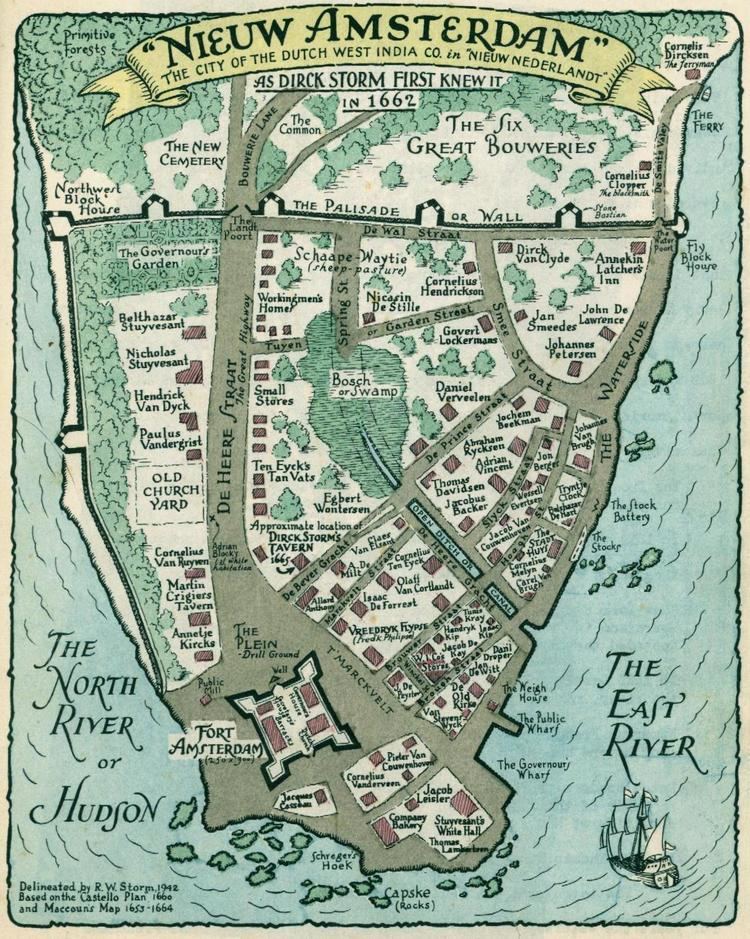
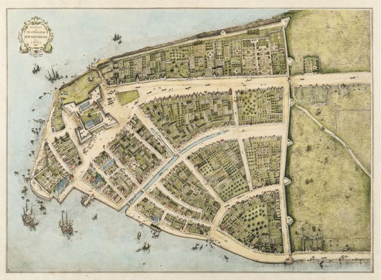
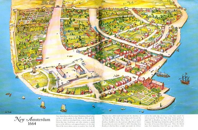
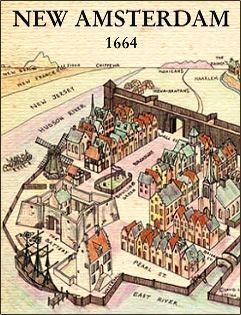
Maps of New Amsterdam
New Amsterdam's beginnings, unlike most other colonies in the New World, were thoroughly documented in city maps. During the time of New Netherland's colonization, the Dutch were Europe's pre-eminent cartographers. Moreover, as the Dutch West India Company's delegated authority over New Netherland was threefold: maintaining sovereignty on behalf of the States General, generating cash flow through commercial enterprise for its shareholders and funding the province's growth; its directors regularly required that censuses be taken. These tools to measure and monitor the province's progress were accompanied by accurate maps and plans. These surveys, as well as grassroots activities to seek redress of grievances, account for the existence of some of the most important of the early documents.
There is a particularly detailed city map called the Castello Plan. Virtually every structure in New Amsterdam at the time is believed to be represented, and by a fortunate coincidence it can be determined who resided in every house from the Nicasius de Sille List of 1660, which enumerates all the citizens of New Amsterdam and their addresses.
The city map known as the Duke's Plan probably derived from the same 1660 census as the Castello Plan. The Duke's Plan includes the earliest suburban development on Manhattan (the two outlined areas along the top of the plan). The work was created for James (1633–1701), the duke of York and Albany, after whom New York City and New York State's capital Albany were named, just after the seizure of New Amsterdam by the British. After that provisional relinquishment of New Netherland, Stuyvesant reported to his superiors that he "had endeavored to promote the increase of population, agriculture and commerce...the flourishing condition which might have been more flourishing if the now afflicted inhabitants had been protected by a suitable garrison...and had been helped with the long sought for settlement of the boundary, or in default thereof had they been seconded with the oft besought reinforcement of men and ships against the continual troubles, threats, encroachments and invasions of the British neighbors and government of Hartford Colony, our too powerful enemies."
The existence of these city maps has proven to be very useful in the archaeology of New York City. For instance, the excavation of the Stadthuys (City Hall) of New Amsterdam had great help in finding the exact location of the building from the Castello map.
Layout
The maps enable a precise reconstruction of the town. Located at the most southern tip of the island of Manhattan, Fort Amsterdam was at the end, which today is surrounded by Bowling Green. battery Park is also reference to it, referring to the batteries or canons.
Broadway was the main street that led out of the town north towards Harlem. The town was surrounded to the north by a wall leading from the eastern to the western shore. The course of this city wall is today Wall Street. A canal led from the harbor inland and was filled in 1676, which today is Broad Street.
The layout of the streets was winding, as in a European city. Only starting from Wall Street going uptown did the typical grid become enforced long after the town ceased to be Dutch. Most of the Financial District overlaps New Amsterdam and has retained the original street layout.
Legacy
The 1625 date of the founding of New Amsterdam is now commemorated in the official Seal of New York City. (Formerly, the year on the seal was 1664, the year of the provisional Articles of Transfer, assuring New Netherlanders that they "shall keep and enjoy the liberty of their consciences in religion", negotiated with the English by Peter Stuyvesant and his council.)
Sometimes considered a dysfunctional trading post by the English who later acquired it from the Dutch, Russell Shorto, author of The Island at the Center of the World, suggests that the city left its cultural marks on later New York and, by extension, the United States as a whole.
Major recent historical research has been based on a set of documents that have survived from that period, untranslated. They are the administrative records of the colony, unreadable by most scholars. Since the 1970s, a professor named Charles Gehring has made it his life's work to translate this first-hand history of the Colony of New Netherland.
The scholarly conclusion has largely been that the settlement of New Amsterdam is much more like current New York than previously thought. Cultural diversity and a mind-set that resembles the American Dream were already present in the first few years of this colony. Writers like Russell Shorto argue that the large influence of New Amsterdam on the American psyche has largely been overlooked in the classic telling of American beginnings, because of animosity between the English victors and the conquered Dutch.
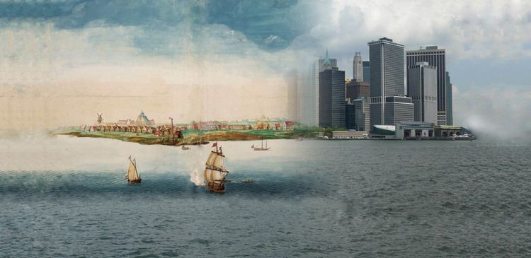
The original 17th-century architecture of New Amsterdam has completely vanished (affected by the fires of 1776 and 1835), leaving only archaeological remnants. The original street plan of New Amsterdam has stayed largely intact, as have some houses outside of Manhattan.
The presentation of the legacy of the unique culture of 17th-century New Amsterdam remains a concern of preservationists and educators. The National Park Service celebrated in 2009 the 400th anniversary of Henry Hudson's 1609 voyage on behalf of the Dutch with the New Amsterdam Trail.
The Dutch-American historian and journalist Hendrik Willem van Loon wrote in 1933 a work of alternative history entitled "If the Dutch Had Kept Nieuw Amsterdam" (in If, Or History Rewritten, edited by J. C. Squire, 1931, Simon & Schuster).
A similar theme, at greater length, was taken up by writer Elizabeth Bear, who published the "New Amsterdam" series of detective stories that take place in a world where the city remained Dutch until the Napoleonic Wars and retained its name also afterwards.
One of New York Broadway theatres is the New Amsterdam Theatre. The name New Amsterdam is also written on the architrave situated on top of the row of columns in front of the Manhattan Municipal Building, commemorating the name of the Dutch colony.
Although no architectural monuments or buildings have survived, the legacy lived on in the form Dutch Colonial Revival architecture. A number of structures in New York city were constructed in the 19th and 20th century in this style, such as Wallabout Market in Brooklyn, South William Street in Manhattan, West End Collegiate Church at West 77th Street, and others.