
Admin. region Oberfranken Elevation 317 m (1,040 ft) Area 26.37 km² Population 7,983 (31 Dec 2008) Dialling code 09134 | Time zone CET/CEST (UTC+1/+2) Local time Friday 10:53 PM Postal code 91077 Administrative region Upper Franconia | |
 | ||
Weather 3°C, Wind NE at 6 km/h, 90% Humidity | ||
Neunkirchen am Brand is a municipality in the district of Forchheim in Bavaria in Germany.
Contents
- Map of 91077 Neunkirchen am Brand Germany
- History
- Districts
- Sights and culture
- Buildings
- Regular events
- Twin towns
- References
Map of 91077 Neunkirchen am Brand, Germany
History
Important dates are the founding of the Canons Regular of Saint Augustine monastery, Neunkirchen am Brand monastery, in 1314 and the conferment of the status as market town in 1410. In 1803 Neunkirchen along with the Prince-Bishopric of Bamberg became part of Bavaria. Between 1886 and 1963 Neunkirchen was located near a train route from Erlangen to Eschenau.
After the Second World War, refugees settled in Neunkirchen and after the establishment of Siemens AG in Erlangen the town experienced a dramatic increase in inhabitants. Numerous suburbs were built around the traditional center of the town.
Neunkirchen is also the home of a number of industrial and trade companies. The largest industrial employer is the axles factory, the Neunkirchener Achsenfabrik (NAF).
Districts
There are the following districts (pop. statistics as of December 31, 2006):
Furthermore, there the farms Vogelhof, Erleinhof and Saarmühle.
Sights and culture
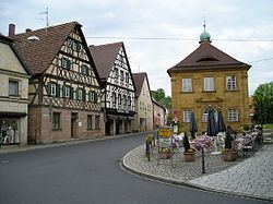
The town is marked by well preserved gates, the former Neunkirchen am Brand Monastery, countless timbered houses and a Middle Age warehouse known as a Zehntscheune. In the district of Großenbuch, the Kugler family operates a restaurant that has existed in that location since the 1500s.
Buildings
In the district of Ermreuth, the former synagogue was restored as a venue for various events. Worth seeing in this districts are also the church and the castle.