
First ascent 5 August 1904 | Elevation 2,519 m Prominence 500 m | |
 | ||
Easiest route from Refugio Vega d'Urriellu. Similar Picos de Europa, Torre de Cerredo, Peña Vieja, Torre Santa, Pico Tesorero | ||
Salto b a s e en el naranjo de bulnes carlos suarez dario barrio
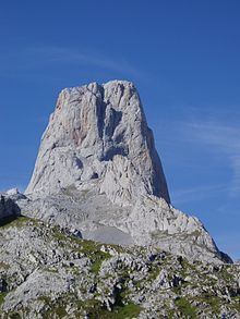
The Naranjo de Bulnes (known as Picu Urriellu in Asturian) is a limestone peak dating from the paleozoic era, located in the Macizo Central region of the Picos de Europa, Asturias (Spain). Its name Picu Urriellu is believed to be derived from the term Los Urrieles which is used to describe the Macizo Central. Naranjo de Bulnes is part of the Cabrales region of Asturias, and lies within the Picos de Europa National Park.
Contents
- Salto b a s e en el naranjo de bulnes carlos suarez dario barrio
- Map of Naranjo de Bulnes 33554 Asturias Spain
- Naranjo de bulnes v a sagitario completa
- Historic ascents
- Reaching the base of the mountain
- Climbing routes
- References
Map of Naranjo de Bulnes, 33554, Asturias, Spain
The first written reference to "Picu Urriellu" as "Naranjo de Bulnes" is credited to the German geologist and engineer, Wilhelm Schulz, who, in 1855, published the first topographic and geological map of Asturias. As far as is known the etymology of this name is not clear, because, historically, the local inhabitants always referred to the mountain as "Picu Urriellu". It has been suggested that the name can be attributed to the orange hue of the limestone from which the peak is formed. The local residents of Bulnes have a saying concerning the contentious name: "No me llameis Naranjo, pues fruto no puedo dar, llamadme Picu Urriellu que es mi nombre natural". (Don't call me Orange tree, because fruit I cannot bear, call me Picu Urriellu which is my natural name).
It has an altitude of 2,529 metres and although it is by no means the highest peak of the Cantabrian mountain range, it can be considered the best-known summit in the world of Spanish mountaineering, especially the 550m high vertical wall of the west face. At its foot lies Vega Urriellu, a glacial valley from the quaternary period.
Naranjo de bulnes v a sagitario completa
Historic ascents
The mountain was first scaled from the north face (by the route now known as the Vía Pidal) on 5 August 1904 by Pedro Pidal y Bernaldo de Quirós, marqués de Villaviciosa de Asturias, accompanied by the shepherd Gregorio Perez, called "El Cainejo" from his place of birth, Caín in León.
The German geology professor and expert mountain climber Gustav Schulze made the second ascent of Urriellu on 1 October 1906 also from the north face, making him the first man to make the climb solo. He was also the first to use climbing pins to rappel down the south face. Used to the large cliffs of the Alps and the Dolomites he described the climb as short and difficult.
By the same face and route as Pidal, Victor Martínez Campillo a local of the nearby town of Bulnes, made the ascent on 31 August 1916. On this climb, Victor recovered parts of the rope that Pedro and Gregorio had left attached to the rock in their descent from the peak. Martínez Campillo made the same climb once again on 22September 1923.
On 19 August 1924, Martínez Campillo also opened a more gentle route, located to the left of the south face, now known as Vía Victor.
On 7 July 1928, the mountaineer Andrés Espinosa from Biscay, scaled the south face alone without ropes. This was only the second climb of this kind on the mountain and the first at a national standard.
One month later, on 8 August, Manuel Martinez Campillo (a cousin of Victor) opened a new path known as the Horizontal Pass. This route was created to the right of the south face and has come to be one of the most used.
On 13 August 1944, two sons of Victor Martínez (Alfonso and Juan) opened the route on the south face known as the "Vía Sur" or the "Martínez Direct Line", which is one of the most used and safest.
On 23 March 1954 Antonio Moreno, Rafael Pellús, Máximo Serna and Agustín Faus from the Peñalara High Mountain Group tried to make the first winter climb. This attempt was called off due to the threat of avalanches.
On 8 March 1956, Ángel Landa Bidarte from the Baracaldo Alpine tourism group and Pedro Udaondo, from the Bilbao Juventus mountain group were the first to succeed in reaching the summit in winter conditions.
On 21 August 1962, the Aragonese mountaineers Alberto Rabadá and Ernesto Navarro completed the first ascent by the difficult West Face.
On 8 February 1973, two parties formed by Miguel Ángel García Gallego (from Murcia) and José Ángel Lucas on one, and César Pérez de Tudela and Pedro Antonio Ortega (from Ardilla) on the other, made the first winter climb by the "Vía Rabadá y Navarro" on the West Face. This ascent was followed closely by the media as that winter had already claimed a few lives and a few spectacular rescues had had to be made.
On 4 September 2009, the brothers Iker and Eneko Pou, conquered Urriellu, after 8 hours of exertion, by the Orbayu route (a path with one of the most difficult cliff faces in the world with a gradient of 8c+/9a)
Reaching the base of the mountain
There are many ways to reach the Vega Urriellu area. Probably the easiest way would be to park the car in the town of Sotres. From there, following the track, head for the "Invernales de Cabao", after that cross the Duje river and from there climb up to the "Pandébano Col" where the track ends and the footpath begins. Once on the footpath head towards the "Majada de la Terenosa" (the shelter of the same name is also located there). The "Colláu Vallejo" is reached from here, which is where the route veers to the south and from where you can begin to make out the Picu Urriellu. From that point on the route continues in a zig-zag fashion up to the "Vega Urriellu" where the shelter of the same name is found, at an altitude of 1960m.
The "Pandébano Col" can also be reached from the town of Bulnes, however this town can only be reached using a footpath or the funicular railway. Although the most direct way of getting to the "Vega Urriellu" from Bulnes would be along the Balcosín channel and the "Majada de Camburero", however, this path is more difficult.
Climbing routes
A list of the most important routes. These make use various entrances and exits from time to time.
West Face
-Rabadá y Navarro (750m, MD+, 6a, A1 [6c+])
-Leiva. (500m, 7a / [6b,A1] )
-Sagitario. (200m, 6b)
-Directísima. (500m, 7b / [6a,A2] )
-Murciana 78. (500m, 7c+ / [6a,A2] )
-Mediterráneo. (500m, [6b,A3] )
-Pilar del Cantábrico. (500m, 8a+ / [6a,A2+] )
-Orbayu: The most difficult "free climb" route yet open on any mountain. It was opened by the Pou brothers in September 2009[1] (500m high with a difficulty of 8c+y9a at some stages).
North Face
-Régil. (700m, V)
-Pidal-Cainejo. (450m, V). (1st ascent of Naranjo de Bulnes, August 5, 1904) East Face
-Cepeda. (350m, 6a)
-Pájaro Loco. (200m, 6b)
-Martínez-Somoano. (250m, V+ expo)
-Amistad con el Diablo. (200m, V+ expo)
-Cainejo. (260m, 7b / [6a+, A1]) South Face
-Nani. (300m, V+)
-Directa Hermanos Martínez. (155m, V-)
-Invicto y Laureado. (160m, 6a+, obl. 6a)
-Me refugio en la bebida. (145m, 7a, obl. 6c)
-Pecadillu. (300m, 6c, obl. 6b).
The descent via the south face (by the South Direct Line) has 4 rappels, after descending through a part of "The Amphitheatre". This is an unstable region and there are loose rocks.