
Country India | ||
 | ||
Main source Mihmyntdu, Jowai1,420 metres (4,660 ft) | ||
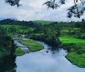
Myntdu river flows through west jaintia hills in meghalaya
Myntdu River is one of the major water bodies in Jaintia Hills District, Meghalaya, locally known as 'ka Tawiar ka Takan' (Our Guardian Angel) in the Pnar dialect. It is a blessing to the residents of the town of Jowai and adjacent places. Its abundant water is used to irrigate the Myntdu Valley, located on the outskirts of Jowai town.
Contents
- Myntdu river flows through west jaintia hills in meghalaya
- Map of Myntdu River Meghalaya
- Myntdu river in west jaintia hills of meghalaya
- Course
- Projects
- References
Map of Myntdu River, Meghalaya
The river, originating at 1,420 metres (4,660 ft) above sea level, is fit for hydro-power development.
Myntdu river in west jaintia hills of meghalaya
Course
The river flows across Jowai, and then through Leshka (where a Hydro Project Dam is being constructed) to reach a village Borghat, within Jaintia Hills, before finally entering Bangladesh, where it is locally called 'Shari'.
Projects
The Myntdu-Leshka Hydro Project Dam (3X42 MW) built across the river, undertaken by MeECL, scheduled in three phases, is located at Leshka, West Jaintia Hills district, Meghalaya near Amlarem, the sub-division headquarters. The project cost is estimated to be around INR 360 crores.