
- elevation 352 m (1,155 ft) - elevation 0 m (0 ft) Area 115 km² | Length 92 km Basin area 819 km² | |
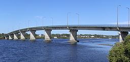 | ||
Bridges Tea Gardens-Hawks Nest Bridge | ||
Bulahdelah myall river free camping nsw
Myall River, an open semi-mature brackish freshwater barrier estuary of the Mid-Coast Council system, is located in the Mid North Coast region of New South Wales, Australia.
Contents
- Bulahdelah myall river free camping nsw
- Map of Myall River New South Wales Australia
- Course and featuresEdit
- EtymologyEdit
- References
Map of Myall River, New South Wales, Australia
Course and featuresEdit
Myall River rises of the southern slopes of Kyle Range within the Great Dividing Range, north northeast of Stroud, and flows generally south southeast then southwest, joined by tributaries including, before reaching its mouth within Port Stephens at Hawks Nest. Port Stephens then empties into the Tasman Sea of the South Pacific Ocean. The river descends 355 metres (1,165 ft) over its 92 kilometres (57 mi) course.
After flowing past the town of Bulahdelah, east of the small settlement of Nerong, the Myall River enters the most southern of the three Ramsar-protected Myall Lakes, Bombah Broadwater, within the Myall Lakes National Park. The flow of the river runs adjacent to the coastline and through both the Little Brasswater and the Brasswater near the towns of Tea Gardens, and Hawks Nest.
Two notable bridges cross the Myall River. The Bulahdelah Bridge, carries the Pacific Highway, across the river north of Bulahdelah and the Singing Bridge crosses the river between Tea Gardens and Hawks Nest..
EtymologyEdit
The word myall is an Australian Aboriginal term for a small silver-grey wattle tree.