
Listing Ultra Elevation 7,276 m Prominence 1,710 m | Easiest route glacier/snow/ice climb First ascent 6 July 1956 | |
 | ||
Similar Masherbrum, Gasherbrum IV, Trango Towers, Mitre Peak - Pakistan, Chogolisa | ||
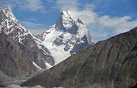
Muztagh Tower (also: Mustagh Tower; Muztagh: ice tower), is a mountain in the Baltoro Muztagh, part of the Karakoram range in Baltistan on the border of the Gilgit–Baltistan region of Pakistan and the Xinjiang Uyghur Autonomous Region of China. It stands between the basins of the Baltoro and Sarpo Laggo glaciers.
Contents
Map of Muztagh Tower
Early prominence
The Mustagh Tower was the subject of a photograph taken by Vittorio Sella during the 1909 Italian expedition to K2. Taken from the upper Baltoro, due southeast of the mountain, the twin summits were perfectly aligned and the mountain was seen as a slender tooth, and looked impregnable. In 1941, the photograph was featured in a book on mountaineering with the caption "The Last Citadel".
First and second ascents
Nearly fifty years after Sella's photo was taken, in 1956, his photograph inspired two expeditions to race for the first ascent. Both teams found their routes less steep than Sella's view had suggested. The British expedition, consisting of John Hartog, Joe Brown, Tom Patey and Ian McNaught-Davis, came from the Chagaran Glacier on the west side of the peak and reached the summit via the Northwest Ridge first on July 6, five days before the French team (fr:Guido Magnone, fr:Robert Paragot, André Contamine, Paul Keller) climbed the mountain from the east. The doctor François Florence waited for the two parties at the camp IV during 42 hours without a radio, when they went, reached the summit and came back to this camp.
Notable ascents and attempts
A lower summit, 7,180 m (23,560 ft) was first climbed in 1984 by the northeast ridge.