
Established 1971 Postal code FSA P0B Area 781.6 km² Local time Wednesday 10:05 AM | Time zone EST (UTC-5) Area code(s) 705 Population 6,588 (2016) | |
 | ||
Weather -12°C, Wind N at 21 km/h, 41% Humidity | ||
The Township of Muskoka Lakes is an area municipality of the District Municipality of Muskoka, Ontario, Canada. It has a year-round population of 6,588.
Contents
- Map of Muskoka Lakes ON Canada
- History and government
- Communities
- Geography and economy
- Demographics
- People from Muskoka
- References
Map of Muskoka Lakes, ON, Canada
History and government
The area now covered by the township was opened for settlement and organized in 1870 into the following geographic (and sometime municipal) townships of Watt, Cardwell, Humphrey, Christie, Medora and Wood.
In 1971, the current municipal structure took hold when Cardwell Township, Watt Township, Medora and Wood Townships, Bala, Port Carling, Windermere and part of Monck Township were merged.
The municipal offices are located in Port Carling.
Communities
The township contains the communities of Bala, Bala Park, Bardsville, Barlochan, Beaumaris, Baysville, Bear Cave, Beatrice, Bent River, Brackenrig, Cedar Village, Dee Bank, Dixon's Corners, Dudley, Duffy, Echo Beach, Ferndale, Foot's Bay, Glen Orchard, Gregory, Gull Rock, Hekkla, Inverness Lodge, Juddhaven, Mendora, Milford Bay, Minett, Morinus, Mortimers Point, Park Beach, Port Carling, Port Keewaydin, Port Sandfield, Raymond, Redwood, Roderick, Rossclair, Rosseau Falls, Rostrevor, Shannon Hall, Sunset Beach, Thorel House, Tomelin Bluffs, Torrance, Ufford, Ullswater, Valley Green Beach, Walkers Point, Willow Beach, Whiteside, Windermere, Woodington, Woodward Station and Ziska.
Geography and economy
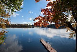
The township is located on Canadian Shield and thus is marked with outcrops of igneous rock and evergreen trees. Although inland from both Lake Huron's Georgian Bay and Lake Simcoe, the township contains the Muskoka Lakes consisting of Lake Muskoka, Lake Rosseau and Lake Joseph, amongst many other smaller lakes.
Timber was initially the greatest economic attraction for the region. The soil is poor and rocky and consequently is not especially suited to agriculture.
As the resource industries dried up, the area soon embraced tourism as its economic base because of its proximity to Toronto and the rest of Southern Ontario. For many Ontarians, this is the centre of cottage country.
Demographics
Racial groups
Religious groups