
Founded 7 December 1836 Population 42,836 (2013) | Congressional district 2nd Website www.co.muscatine.ia.us Area 1,163 km² | |
 | ||
University Muscatine Community College Points of interest Wildcat Den State Park, Weed Park, Deep Lakes Park, Clark's Ferry Recreatio, Muscatine History & Industry | ||
Timelapse august 2 2015 supercell from central muscatine county iowa
Muscatine County is a county located in the U.S. state of Iowa. As of the 2010 census, the population was 42,745. The county seat is Muscatine. The southeastern border is formed by the Mississippi River.
Contents
- Timelapse august 2 2015 supercell from central muscatine county iowa
- Map of Muscatine County IA USA
- History
- Geography
- Adjacent counties
- Major highways
- Other roadways
- 2010 census
- 2000 census
- Unincorporated communities
- Population ranking
- References
Map of Muscatine County, IA, USA
Muscatine County comprises the Muscatine, IA Micropolitan Statistical Area, which is included in the Davenport-Moline, IA-IL Combined Statistical Area.
History
Muscatine County was formed on December 7, 1836 as a part of Wisconsin Territory, and split off from Des Moines County. One history of the county claims it was named for Muscatine Island in the Mississippi River. The island lies opposite Muscatine County and was believed to be named after the Mascouten tribe, Algonquian-speaking Native Americans who lived in the area before being driven west by settler encroachment and other tribes.
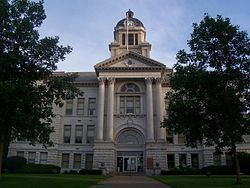
In 1833, Colonel George Davenport of Illinois sent three representatives into the territory to establish a trade post. They were the first European Americans to settle there. In the same year, James W. Casey and John Vanatta came to the area. They opened a supply depot for steamboats on June 1, 1833, and named it Casey’s Woodpile. (The steamboats burned wood.) Muscatine County officially became a part of Iowa Territory on the date the territory was established and split from Wisconsin Territory, on July 4, 1838. The first public land sale was held in November 1838. One year later, the construction of the courthouse and a jail was begun. A second jail, referred to as the "Old Jail", was built in 1857.
On December 23, 1864, the courthouse was complete gutted by a fire and, within two years, a new structure was completed on the same site. The construction of the courthouse still used today was completed on September 26, 1907.
Geography
According to the U.S. Census Bureau, the county has a total area of 449 square miles (1,160 km2), of which 437 square miles (1,130 km2) is land and 12 square miles (31 km2) (2.6%) is water.
Adjacent counties
Major highways
Other roadways
2010 census
The 2010 census recorded a population of 42,745 in the county, with a population density of 99.7154/sq mi (38.5003/km2). There were 17,910 housing units, of which 16,412 were occupied.
2000 census
As of the census of 2000, there were 41,722 people, 15,847 households, and 11,283 families residing in the county. The population density was 95 people per square mile (37/km²). There were 16,786 housing units at an average density of 38 per square mile (15/km²). The racial makeup of the county was 90.72% White, 0.70% Black or African American, 0.31% Native American, 0.83% Asian, 0.02% Pacific Islander, 6.05% from other races, and 1.37% from two or more races. 11.92% of the population were Hispanic or Latino of any race.
There were 15,847 households out of which 34.80% had children under the age of 18 living with them, 57.90% were married couples living together, 9.30% had a female householder with no husband present, and 28.80% were non-families. 24.10% of all households were made up of individuals and 9.90% had someone living alone who was 65 years of age or older. The average household size was 2.59 and the average family size was 3.07.
In the county, the population was spread out with 26.90% under the age of 18, 8.60% from 18 to 24, 28.80% from 25 to 44, 22.80% from 45 to 64, and 12.90% who were 65 years of age or older. The median age was 36 years. For every 100 females there were 98.10 males. For every 100 females age 18 and over, there were 94.90 males.
The median income for a household in the county was $41,803, and the median income for a family was $48,373. Males had a median income of $36,329 versus $24,793 for females. The per capita income for the county was $19,625. About 6.30% of families and 8.90% of the population were below the poverty line, including 10.70% of those under age 18 and 7.70% of those age 65 or over.
Unincorporated communities
Population ranking
The population ranking of the following table is based on the 2010 census of Muscatine County.