
Easiest route Rock scramble First ascent August 1938 | Elevation 4,509 m Prominence 2,969 m | |
 | ||
Isolation 539 kilometres (335 mi) Listing Country high pointUltra Similar Mount Giluwe, Bismarck Range, Tavurvur, Puncak Jaya, Rabaul caldera | ||
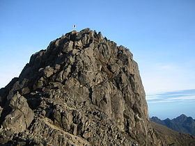
Mount wilhelm 4509m papua new guinea sunrise
Mount Wilhelm, or Enduwa Kombuglu, or Kombugl'o Dimbin at 4,509 metres (14,793 ft) is the highest mountain in Papua New Guinea. It is part of the Bismarck Range and the peak is the point where three provinces, Simbu, Jiwaka and Madang, meet. The peak is also known as Enduwa Kombugluor Kombugl'o Dimbin in the local Kuman language, a Papuan language.
Contents
- Mount wilhelm 4509m papua new guinea sunrise
- Map of Mt Wilhelm Papua New Guinea
- Kundiawa to mount wilhelm secondary apr2015
- Discovery
- WWII bomber crash
- Climbing deaths
- Ascending
- References
Map of Mt Wilhelm, Papua New Guinea
The mountain is on the island of New Guinea, which incorporates Papua New Guinea and the Indonesian province of Papua. It is surpassed by Puncak Jaya, 4,884 m (16,024 ft), and several other peaks in Indonesian Papua.
Mount Wilhelm may be claimed as the highest mountain in Oceania (including Australia and New Zealand), on account of Indonesia being partially in Asia. A Seven Summits list sometimes includes Mount Wilhelm.
Kundiawa to mount wilhelm secondary apr2015
Discovery
It was not until August 1938 when Leigh Vial, a government patrol officer, and two Papuan New Guineans, his "Mangi mastas", "Namba Wan Bare Kuakawa" and "Gend" from "Mondia Nigle", made the first recorded ascent. It was noted by Vial that even though the mountain was close to the equator, snow existed on top of the mountain at the time of ascent.
WWII bomber crash
During the Second World War in the early hours of May 22, 1944, an American F-7A (a converted B-24 Liberator) named "Under Exposed" crashed into the mountain while flying too low. The aircraft left from Nadzab airbase, close to Lae, and had been assigned for a reconnaissance mission to photograph Padaidori Island in Dutch New Guinea. Around 0400 the plane crashed into Wilhelm at about 13,000 feet (4,000 m) above the twin lakes. All crew were killed and most of the wreckage landed in the topmost lake although some can still be seen today. The only remains at the site are from the plane, as all bodies have been recovered.
Climbing deaths
A number of people have died trying to climb the mountain. An Australian Army Sergeant, Christopher Donnan, died in December 1971 when he fell down a steep slope. There is a plaque at the point where he was last seen. In August 1995 an Israeli backpacker died after he sprained his ankle and stayed behind while his group continued. He subsequently wandered off the track and fell into a ravine in the pre-dawn darkness. His body was found about a week later. On 30 July 2005 58-year-old Bob Martin, a marketing manager at Air Niugini, suffered a heart attack and died near the summit. In 2001, a student from Muaina High School (Muaina High school Mt Wilhelm Expedition) died at Piunde-foot of Mt Wilhelm. He was later found to be an asthmatic patient. Another, local Papua New Guinean from Tari, in Southern Highlands Province died few meters south of Christopher Donnan plaque in 2007. Local sources revealed that the deceased was very ignorant of the warning and was in his sporting suit;sport wear; T-shirt, and a Dunlop s.shoe.He was covered by debris and fallen rock fragments forming a talus at the base of the southern tip of the Christopher Donnan section.
Ascending
Mount Wilhelm is the most accessible mountain to climb in Papua New Guinea. There are two routes to the top. The most common route starts from the village of Keglsugl at the end of the road from Kundiawa in Simbu province. A harder hike and climb starts from the village of Ambullua in the Western Highlands province.
The Keglsugl route involves climbing up and through a mountain rain forest and then along an alpine grassland glacial valley to the twin lakes of Piunde and Aunde. At Piunde there are two huts, one being an old Australian National University monitoring station and the other an 'A-Frame' hut. Though not a technical climb, various sections can be treacherous in wet weather. The climb is usually started during the night; the ascent and subsequent descent can take anywhere from nine to 24 hours. Reaching the peak at dawn allows a better chance of clear weather.
The other route from Ambullua is a much harder 4-day hike.