
Prominence 46 m | Elevation 1,192 m | |
 | ||
Similar Mount Jackson, Mount Willard, Mount Eisenhower, Mount Willey, Mount Pierce | ||
Mount webster and mount jackson
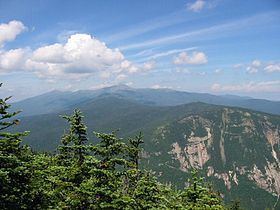
Mount Webster is a mountain located on the border between Coos County and Carroll County, New Hampshire. The mountain, formerly called Notch Mountain, is named after Daniel Webster (1782–1852), and is the southwesternmost of the Presidential Range of the White Mountains. Mount Webster is flanked to the northeast by Mount Jackson; to the southwest it faces Mount Willey across Crawford Notch.
Contents
- Mount webster and mount jackson
- Map of Mt Webster Beans Grant NH 03589 USA
- New hampshire mount webster mount washington lion head
- References
Map of Mt Webster, Bean's Grant, NH 03589, USA
The west face of Mount Webster drains directly into the Saco River, thence into the Gulf of Maine at Saco, Maine. The north and southeast faces drain into the Saco via Silver Cascade and Webster Brook respectively.
Mount Webster is on the western boundary of the Presidential Range - Dry River Wilderness. The Appalachian Trail, a 2,170-mile (3,500-km) National Scenic Trail from Georgia to Maine, runs along the ridge of the Presidentials, across the summit of Webster.